 Filter: Categories of Wisconsin Historical Images
Filter: FORMAT_TYPE of prints, photomechanical
Filter: Subject of missions
Filter: Categories of Wisconsin Historical Images
Filter: FORMAT_TYPE of prints, photomechanical
Filter: Subject of missions
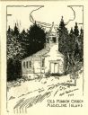
| Date: | 1916 |
|---|---|
| Description: | Illustration of the Old Mission Congregational Church. The church was built in 1832 for a mission founded by Frederick Ayer in 1830. It is said to be the o... |

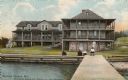
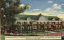
| Date: | |
|---|---|
| Description: | The Old Mission Inn, originally built as a mission house in 1832 by the Congregational mission established by Frederick Ayer in 1830. In later years furthe... |
| Date: | 1910 |
|---|---|
| Description: | View from pier towards the Old Mission in La Pointe on Madeline Island. Men are sitting at the shoreline. Caption reads: "Apostle Islands, Wis. Madeline Is... |
| Date: | 1865 |
|---|---|
| Description: | View of a mission house, erected between 1862 and 1873. |

| Date: | 1840 |
|---|---|
| Description: | This map surveyed under the direction of Captain Thomas J. Cram is one in a series of seventeen that accompanied Cram's report on the Fox-Wisconsin river s... |
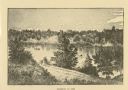
| Date: | 1876 |
|---|---|
| Description: | Distant view of Neshotah Mission. River with boaters, two people standing on riverbank, mission on hill in background. |
| Date: | 1940 |
|---|---|
| Description: | Winnebago Indian Mission School of the Evangelical and Reformed Church. This boarding school for Indian children was established in 1917 near Black River F... |
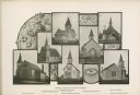
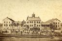
| Date: | 1904 |
|---|---|
| Description: | Composite photograph of views of seven Washburn churches, including Mehtodist Church, Swedish Mission Church, Congregational Church, Norwegian Lutheran Chu... |

| Date: | 1856 |
|---|---|
| Description: | Receipt issued by the American Board of Commissioners of Foreign Missions to Frederick Smith for a contribution of ten cents from the Sabbath School of the... |

| Date: | |
|---|---|
| Description: | Exterior view of the Cameron Mission, a home for rescued Asian (Chinese and Japanese) slaves in San Francisco. Some of the residents are posed in a group a... |

| Date: | 1942 |
|---|---|
| Description: | These three maps depict the locations of French missions and French forts in Wisconsin, as well as the French place names in the state. |

| Date: | 1939 |
|---|---|
| Description: | This map shows the towns to Gingles, Sanborn, and Guney as well as Chequamegon Bay, Kakagon River, White River, Marengo River, Bad River, Potato River, Vau... |

| Date: | 1911 |
|---|---|
| Description: | This map shows swamps, railroads, rivers, roads, the Catholic Mission Reserve, the day school, and the Agency Reserve. Lake Superior is labeled. An inset m... |

| Date: | 1845 |
|---|---|
| Description: | This map shows lakes, rivers, Chippewa land, the U.S. Mineral Land Agency, boundary between U.S. and Canada, Methodist and Catholic missions, and American ... |

| Date: | 1954 |
|---|---|
| Description: | This map shows the location of Catholic churches, missions, and shrines. The map is color coded and includes a key in the bottom left corner. The back of t... |

| Date: | 1946 |
|---|---|
| Description: | This map shows scenes from America's history with names of historical events superimposed on a map of the United States. |
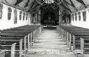
| Date: | 1924 |
|---|---|
| Description: | Postcard of the church interior, with pews, altar, nave, statues, and paintings. The church ceiling is decorated with garlands and wreaths. Caption reads: ... |
If you didn't find the material you searched for, our Library Reference Staff can help.
Call our reference desk at 608-264-6535 or email us at:
