 Filter: Categories of Wisconsin Historical Images
Filter: FORMAT_TYPE of prints, photomechanical
Filter: Subject of travel
Filter: Subject of lakes
Filter: Categories of Wisconsin Historical Images
Filter: FORMAT_TYPE of prints, photomechanical
Filter: Subject of travel
Filter: Subject of lakes

| Date: | 1941 |
|---|---|
| Description: | Official highway map of Wisconsin, "the playground of the Midwest," showing the state transportation network prior to World War II. |

| Date: | 1934 |
|---|---|
| Description: | Tourist camp at Lakeside Park on Lake Winnebago. |

| Date: | 1884 |
|---|---|
| Description: | Cover art for a pamphlet advertising The Apostle Islands and Lake Superior. The upper half of the artwork depicts a sunset view of Lake Superior, and the b... |
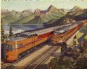
| Date: | 1946 |
|---|---|
| Description: | Reproduction of a painting depicting an Olympian Hiawatha locomotive and an Olympian Hiawatha observation car traveling in the western United States. A man... |

| Date: | 1953 |
|---|---|
| Description: | This map shows locations of State Medical Society, nine medical facilities, two University of Wisconsin buildings, four transportation centers, and five ho... |

| Date: | 1975 |
|---|---|
| Description: | This map shows transportation routes taken by public transit. Includes a key to bus routes, schedule, and transit information. Includes labels for streets,... |

| Date: | 1946 |
|---|---|
| Description: | This colored road map shows automobile roads in Wisconsin as well as portions of nearby states. Information on the quality and type of any road shown (Inte... |

| Date: | 1948 |
|---|---|
| Description: | This colored road map shows automobile roads in Wisconsin as well as portions of nearby states.Information on the quality and type of any road shown (bitum... |

| Date: | 1948 |
|---|---|
| Description: | This colored road map shows automobile roads in Wisconsin as well as portions of nearby states. The map is organized such that a single map of Wisconsin is... |

| Date: | 1956 |
|---|---|
| Description: | This colored road map shows automobile roads in Wisconsin as well as portions of nearby states. The map is organized such that a single map of Wisconsin is... |

| Date: | 1959 |
|---|---|
| Description: | This colored road map shows roads in Wisconsin as well as portions of nearby states. Information on the quality and type of any road shown (expressways, St... |

| Date: | 1962 |
|---|---|
| Description: | This tourist-oriented road map shows federal highways, state highways, county roads, and county lines in the "Blue Diamond Resort Area," a scenic space enc... |

| Date: | 1963 |
|---|---|
| Description: | This colored road map shows automobile roads in Wisconsin as well as portions of nearby states. The map is organized such that a single map of Wisconsin is... |

| Date: | 1952 |
|---|---|
| Description: | This colored map shows the entire state, along with counties in states bordering Wisconsin. There is a key to "Wisconsin Railroads," with initials identify... |
If you didn't find the material you searched for, our Library Reference Staff can help.
Call our reference desk at 608-264-6535 or email us at: