 Filter: Categories of Wisconsin Historical Images
Filter: Subject of Animals
Filter: Subject of men
Filter: Subject of maps
Filter: Categories of Wisconsin Historical Images
Filter: Subject of Animals
Filter: Subject of men
Filter: Subject of maps

| Date: | 1655 |
|---|---|
| Description: | Frontispiece to Newe Welt vnd americanische Historien (1655). |

| Date: | 1938 |
|---|---|
| Description: | A colorful pictorial map of Australia, featured on the front and back cover of a special Australian edition of International Trail. |
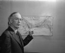
| Date: | 09 20 1947 |
|---|---|
| Description: | James L. Clark, Madison city health inspector, shown pointing to a map of Madison marked with X's signifying places with rat infestation. |
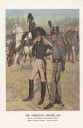
| Date: | 1976 |
|---|---|
| Description: | "A general staff officer stands in the left foreground in the single-breasted blue coat with black herringbone false buttonholes on the chest and cuffs and... |
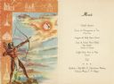
| Date: | 1952 |
|---|---|
| Description: | Front cover and menu page for a banquet given by the Instituto Mexicano del Seguro Social to the senior delegates to the fourth reunion of the Inter-Americ... |

| Date: | 07 21 1951 |
|---|---|
| Description: | Luncheon menu for the S.S. Argentina, with a map of Argentina with spot illustrations for the provinces and featured products or symbols, the coat o... |
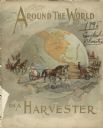
| Date: | 1895 |
|---|---|
| Description: | Front cover of catalog for Deering Harvester Company. The headline reads: "Around the World on a Harvester," and features an illustration of men and women ... |
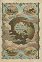
| Date: | 1895 |
|---|---|
| Description: | Back cover of catalog for Deering Harvester Company. Features an illustration of men, women and children riding on agricultural machinery pulled by horses.... |
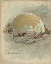
| Date: | 1884 |
|---|---|
| Description: | Front cover of catalog featuring a color illustration of a globe among clouds. Small oval inset illustrations are of farmers working in fields in Africa, A... |

| Date: | |
|---|---|
| Description: | Group portrait of a group of men posing sitting and standing around a table. There are several female nude photographs hanging on the wall behind them. |

| Date: | 1703 |
|---|---|
| Description: | Map of the Golf of Mexico and surrounding countries from the Great Lakes down to the northern most parts of South America. L'Isle labels cities, towns, and... |

| Date: | 1715 |
|---|---|
| Description: | One of Herman Moll's most famous maps, often referred to as The Codfish Map, it shows rivers and portages, cities, Indian villages, wind directions, routes... |

| Date: | 1758 |
|---|---|
| Description: | This map of the north-west hemisphere shows the cities, lakes, rivers, mountains, and political borders. In the upper left corner sits a decorative cartouc... |

| Date: | 1746 |
|---|---|
| Description: | This world map from the German mathematician, historian, and geographer Johann Matthias Hase shows the major cities, islands, and the major political divis... |

| Date: | 1685 |
|---|---|
| Description: | A detailed map of the western hemisphere showing cities, settlements, Native American land, rivers, lakes, mountains, the Great Lakes, and California as an... |

| Date: | 1746 |
|---|---|
| Description: | Detailed map of the western hemisphere and part of Africa and Europe. Islands, cities, settlements, rivers, lakes, countries, and regions are marked. Mount... |

| Date: | 1759 |
|---|---|
| Description: | Map of North and South America showing regions, colonies, cities and settlements, rivers, lakes, and Native American land. Near the bottom left an inset ma... |

| Date: | 1636 |
|---|---|
| Description: | Map of North America, divided into regions, and showing some rivers, lakes, settlements, cities, mountains, and Native American land. Of the Great Lakes on... |

| Date: | 1713 |
|---|---|
| Description: | Map showing the regions explored by Robert de La Salle between 1681 and 1686, as well as the route La Salle, and later Henri Joutel, took, moving north fro... |

| Date: | 1719 |
|---|---|
| Description: | This extremely detailed and ornate map shows the cities, Native American land, mountains, lakes, rivers, and European claims of North America. An inset map... |
If you didn't find the material you searched for, our Library Reference Staff can help.
Call our reference desk at 608-264-6535 or email us at: