 Filter: Categories of Wisconsin Historical Images
Filter: Subject of Archaeological sites
Filter: Subject of indians of north america
Filter: Categories of Wisconsin Historical Images
Filter: Subject of Archaeological sites
Filter: Subject of indians of north america
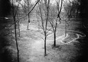
| Date: | 08 1905 |
|---|---|
| Description: | A visitor takes in the sight of three linear burial mounds at the Sure-Johnson mound group south of McFarland, Wisconsin. |
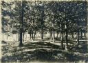
| Date: | 1919 |
|---|---|
| Description: | Elevated view of a four-footed American Indian effigy mound on the grounds of the Mendota State Hospital (Mendota Mental Health Institute). |

| Date: | 1954 |
|---|---|
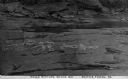
| Description: | Raddatz Rockshelter and Natural Bridge, known by archaeologists as 47 SK-5. The bridge is made of sand stone, reaching 35 feet in height, and is the larges... |
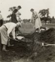
| Date: | 05 30 1931 |
|---|---|
| Description: | W.P. and Vivian Morgan, Grace Rollins and ? Mills excavate a burial mound in the Outlet group at the foot of Lake Monona. |
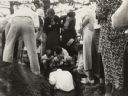
| Date: | 1935 |
|---|---|
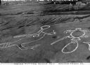
| Description: | Members of the Wisconsin Outing Club watch the excavation of a burial mound at the Outlet group in 1935. |
| Date: | |
|---|---|
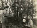
| Description: | Charles E. Brown (left), directs excavation of a goose effigy mound at the Willow Drive mound group on the University of Wisconsin-Madison campus. |
| Date: | |
|---|---|
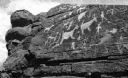
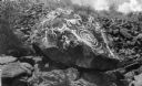
| Description: | An elevated view of Native American picture rocks, also known as petroglyphs. Caption reads: "Indian Picture Rocks No. 1. Smith's Ferry, PA." |
| Date: | |
|---|---|
| Description: | An elevated view of Native American picture rocks, also known as petroglyphs. Caption reads: "Indian Picture Rocks No. 2. Smith's Ferry, PA." |
| Date: | |
|---|---|
| Description: | An elevated view of Native American picture rocks, also known as petroglyphs. Caption reads: "Indian Picture Rocks No. 3. Smith's Ferry, PA." |
| Date: | |
|---|---|
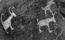
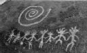
| Description: | A view of Native American petroglyph rock carvings near Tucson. |
| Date: | |
|---|---|
| Description: | Native American petroglyph rock carvings near Tucson. |
| Date: | |
|---|---|
| Description: | Native American petroglyph rock carving near Tucson. |
| Date: | |
|---|---|
| Description: | A view of Native American petroglyph rock engravings near Tucson. |

| Date: | 1921 |
|---|---|
| Description: | A man sits on top of a mound near Trade Lake. |

| Date: | 1921 |
|---|---|
| Description: | Three men and four children standing on top of a mound near Round Lake. |

| Date: | 1927 |
|---|---|
| Description: | Three men and two women sit on top of a mound near Trade Lake. |

| Date: | 1930 |
|---|---|
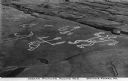
| Description: | A map of the site of a Native American village with a complex of linear raised garden beds and cache pits near Leeman. Also shown are a farmstead, road, an... |

| Date: | 1791 |
|---|---|
| Description: | Small map of an abandoned Native American town and fort at the junction of the Ohio and Muskingum River. It shows the fortifications, an outline of the tow... |
If you didn't find the material you searched for, our Library Reference Staff can help.
Call our reference desk at 608-264-6535 or email us at:

