 Filter: Categories of Wisconsin Historical Images
Filter: Subject of Battles
Filter: Creator Name of Unknown
Filter: Subject of water
Filter: Categories of Wisconsin Historical Images
Filter: Subject of Battles
Filter: Creator Name of Unknown
Filter: Subject of water
| Date: | 1845 |
|---|---|
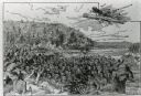
| Description: | Illustration of Chippewa and Sioux Indians battling each other at the Brule River. Wood engraving from Armstrong, "Early Life Among The Indians." |
| Date: | 1845 |
|---|---|
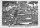
| Description: | Engraving depicting the defeat of Black Hawk by General Henry Atkinson at the Battle of Bad Axe on August 2, 1832. The engraving depicts Federal Regulars a... |
| Date: | |
|---|---|
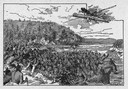
| Description: | An illustration titled "The Battle of the Brule" based on an 1840's battle between the Ojibwe and Dakota Sioux over territory in the Ashland, Wisconsin are... |
| Date: | 12 07 1941 |
|---|---|
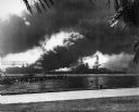
| Description: | Sailors clear the stern of the battleship USS West Virginia in berth F-6 at Pearl Harbor, most likely after it was hit by at least a few of the 7 to... |

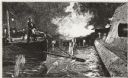
| Date: | 12 07 1941 |
|---|---|
| Description: | The forward magazines of the USS Shaw exploding after a Japanese bomb set the fore aflame as it sat in dock at Pearl Harbor. The midships and stern ... |

| Date: | 12 07 1941 |
|---|---|
| Description: | Capsized USS Oklahoma at Pearl Harbor. The Oklahoma was hit with a large number of Japanese aerial torpedoes which ripped an opening across ... |
| Date: | 12 07 1941 |
|---|---|
| Description: | The USS Nevada in berth at Pearl Harbor with the USS Shaw burning in the background after its forward deck was hit with a Japanese bomb. |
| Date: | 12 07 1941 |
|---|---|
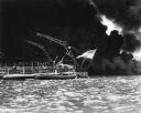
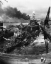
| Description: | The remains of the USS Cassin and the USS Downes floating in front of the USS Pennsylvania in dock at Pearl Harbor. On the left is th... |
| Date: | 12 07 1941 |
|---|---|
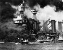
| Description: | Sailors in a motor launch attempt a rescue of survivors from the water alongside the sunken battleship USS West Virginia during or shortly after the... |
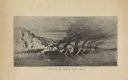
| Date: | |
|---|---|
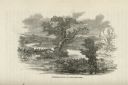
| Description: | Illustration of an area with water and trees showing men hiding in the brush. |
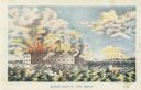
| Date: | 1861 |
|---|---|
| Description: | Color lithograph of the fort in the midst of the bombardment, published by Bingham & Dodd, Hartford, Connecticut. |
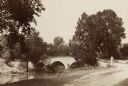
| Date: | 1890 |
|---|---|
| Description: | Site of the Battle of Antietam, the Burnside Bridge. |

| Date: | 1880 |
|---|---|
| Description: | A scene from a panoramic painting of Grant's assault on Vicksburg. |
| Date: | |
|---|---|
| Description: | A halftone lithograph of the Battle of Grand Gulf, Mississippi. |
| Date: | |
|---|---|
| Description: | Sinking of the "Albemarle." Lieut. Cushing (?) torpedoing the ALBEMARLE. |
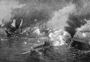
| Date: | |
|---|---|
| Description: | A painting of 'The Battle Between the Monitor and the Merrimac.' The work commemorates the Battle of Hampton Roads, fought on March 8–9, 1862, and depicts ... |
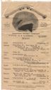
| Date: | 09 07 1913 |
|---|---|
| Description: | One-page menu printed on a wide silk ribbon to commemorate the victory of Commodore Oliver Hazard Perry at the Battle of Lake Erie during the War of 1812, ... |
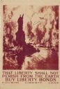
| Date: | 1918 |
|---|---|
| Description: | United States government bonds poster in the Fourth Liberty Loan "B" series. "Buy Liberty Bonds. Fourth Liberty Loan." Depicts enemy aircraft bombing New Y... |

| Date: | 1755 |
|---|---|
| Description: | Map of New England, with three inset maps of Fort Oswego, Fort du Quesne, and Fort Frederick. It shows colonies, a few cities, forts (marked as French or E... |

| Date: | 1775 |
|---|---|
| Description: | Map of Boston and surrounding regions, from Massachusetts Bay to the Connecticut River, and including part of southern New Hampshire. It shows the colonies... |
If you didn't find the material you searched for, our Library Reference Staff can help.
Call our reference desk at 608-264-6535 or email us at: