 Filter: Categories of Wisconsin Historical Images
Filter: Subject of Battles
Filter: Subject of hills
Filter: Categories of Wisconsin Historical Images
Filter: Subject of Battles
Filter: Subject of hills
| Date: | 10 03 1862 |
|---|---|
| Description: | "Combined Confederate attack upon [Batteries] Robinette and Davis the attack on Battery Robinette being defeated and that on Davis resulting in the defeat ... |
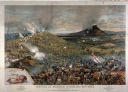
| Date: | 1886 |
|---|---|
| Description: | Lithographed advertising poster for the McCormick Harvesting Machine Company showing the Civil War battle of Mission Ridge. Features an inset with a small ... |
| Date: | |
|---|---|
| Description: | The Battle of Chattanooga from the Milwaukee-based American Panoramic Company's cyclorama "The Storming of Missionary Ridge." |
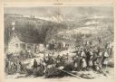
| Date: | 12 17 1862 |
|---|---|
| Description: | Illustration depicting a battle. In the foreground injured soldiers are gathered on and around the porch and yard of a house. In the background are columns... |

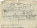
| Date: | 1767 |
|---|---|
| Description: | Map of the north east coast of America, showing colonial borders, cities, Native American land, lakes, rivers, and a few hills and mountains. Illustrated t... |

| Date: | 1780 |
|---|---|
| Description: | Detailed topographical and political map of the area from Lake Champlain to Albany and the Hudson River. Relief is shown through hachures. The map shows ci... |

| Date: | 10 1776 |
|---|---|
| Description: | Broadside map showing the British invasion of New York city in August and September of 1776. The map shows important cities, forts, roads, hills, mountains... |

| Date: | 03 1777 |
|---|---|
| Description: | Map showing the British and Hessian attack on Fort Washington in November of 1776. The movements and fortifications of the British and Hessian troops appea... |

| Date: | 04 1777 |
|---|---|
| Description: | Map showing the area from Newtown, Pennsylvania to Kingston, New Jersey, with routes and battles of British (red) and American forces (blue). The map inclu... |
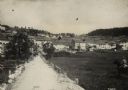
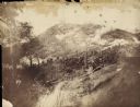
| Date: | |
|---|---|
| Description: | View of town of Lavarone in the southwest battlefront. |

| Date: | |
|---|---|
| Description: | The ruins of a totally destroyed Russian village. |

| Date: | 09 28 1914 |
|---|---|
| Description: | Town of Saales. Bombarded by the French on September 28. |

| Date: | |
|---|---|
| Description: | Town of Saales in Alsace, with damaged buildings and debris lying on the ground. A ladder in front of the damaged building in the foreground reaches the ro... |

| Date: | |
|---|---|
| Description: | Town of Saales in the Vosges. Debris is on the ground and buildings are damaged. There are wooded hills in the distance beyond the town. The town hall (Rat... |

| Date: | |
|---|---|
| Description: | Emergency bridge over the Pruth (River) near Sanda Gora. |

| Date: | |
|---|---|
| Description: | The Polish Legion was a volunteer force of ethnic Poles raised by the Austro-Hungarian army in 1914. It had various incarnations during the war, and its me... |
If you didn't find the material you searched for, our Library Reference Staff can help.
Call our reference desk at 608-264-6535 or email us at:
