 Filter: Categories of Wisconsin Historical Images
Filter: Subject of Battles
Filter: Subject of rivers
Filter: Categories of Wisconsin Historical Images
Filter: Subject of Battles
Filter: Subject of rivers
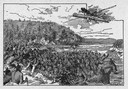
| Date: | 1845 |
|---|---|
| Description: | Illustration of Chippewa and Sioux Indians battling each other at the Brule River. Wood engraving from Armstrong, "Early Life Among The Indians." |
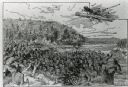
| Date: | |
|---|---|
| Description: | An illustration titled "The Battle of the Brule" based on an 1840's battle between the Ojibwe and Dakota Sioux over territory in the Ashland, Wisconsin are... |
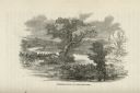
| Date: | |
|---|---|
| Description: | Illustration of an area with water and trees showing men hiding in the brush. |
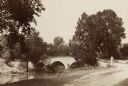
| Date: | 1890 |
|---|---|
| Description: | Site of the Battle of Antietam, the Burnside Bridge. |

| Date: | 1880 |
|---|---|
| Description: | A scene from a panoramic painting of Grant's assault on Vicksburg. |
| Date: | |
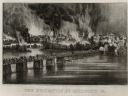
|---|---|
| Description: | Currier & Ives lithograph of the fall of Richmond, April 2, 1865. |
| Date: | |
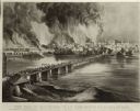
|---|---|
| Description: | "The Evacuation of Richmond Virginia. By the Government of the Southern Confederacy on the Night of April 2nd 1865." Before evacuating, the Confederates se... |

| Date: | 1864 |
|---|---|
| Description: | (U.S. 39th Cong. 1stt Sess. Report of Chief engineer) The legend in the upper left corner contains a brief resume of each day's action while the map sho... |

| Date: | 1850 |
|---|---|
| Description: | A hand-colored map showing portions of present-day Iron and Vilas counties north of the Manitowish River as part of the Upper Peninsula of Michigan. The Wi... |

| Date: | 1863 |
|---|---|
| Description: | A general map of the southeastern United States showing Missouri, Kentucky, West Virginia, Virginia, North Carolina, South Carolina, Georgia, Florida, Alab... |

| Date: | 1864 |
|---|---|
| Description: | This map of the battlefield on the North Anna River at Hanover Junction illustrates the Union positions in blue and Confederate positions in red. Roads, ra... |

| Date: | 1864 |
|---|---|
| Description: | This colored map of the southern and eastern states shows locations of battles and skirmishes from 1861 through May 1864 with red dots or red underlining o... |

| Date: | 1865 |
|---|---|
| Description: | This map of the Bentonville, N.C., battlefield illustrates the positions of the Union and the Confederate troops, roads, rivers, vegetation, and the names ... |

| Date: | 10 13 1943 |
|---|---|
| Description: | Aerial view of two Consolidated B-24 Liberator warplanes taken from another airplane during the Alexishafen strike. On the left is Colonel Arthur Rogers' l... |

| Date: | 05 01 1899 |
|---|---|
| Description: | Map showing the Schuylkill River with roads, ferries, and points of interest from Valley Forge to Philadelphia, Pennsylvania as it appeared during the Revo... |

| Date: | 1862 |
|---|---|
| Description: | This map shows the plan of the siege of Yorktown and the Battle of Williamsburg. The map also shows fortifications, towns, roads, houses, names of resident... |

| Date: | 1865 |
|---|---|
| Description: | This map shows U.S. cavalry positions in yellow, Confederate infantry positions in blue, and Confederate cavalry positions in red. The map also shows roads... |

| Date: | 1777 |
|---|---|
| Description: | Map showing the Hudson River in three sections, from New York City up through Lake Champlain, including cities, forts, roads, topographical features, and n... |

| Date: | 1733 |
|---|---|
| Description: | This map of North America shows settlements, rivers, lakes, Native American land, trade winds, and numerous topographical features such as forests and moun... |

| Date: | 1770 |
|---|---|
| Description: | Map of North America from the Great Lakes to the northern portion of South America. It shows cities, Native American land, mountains, swamps, lakes, rivers... |
If you didn't find the material you searched for, our Library Reference Staff can help.
Call our reference desk at 608-264-6535 or email us at: