Filter: Categories of Wisconsin Historical Images
Filter: Subject of Cities and towns
Filter: Community of Madison
Filter: Categories of Wisconsin Historical Images
Filter: Subject of Cities and towns
Filter: Community of Madison

| Date: | 1851 |
|---|---|
| Description: | Plat map of the Town of Madison (Township 7N, Range 9E), from Volume 4, Federal Survey Plat Books. |
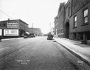
| Date: | 09 29 1945 |
|---|---|
| Description: | Richard Ela Company, 744 Williamson Street, selling industrial and welding equipment and supplies and Hanley Implement Company, 740 Williamson Street, sell... |
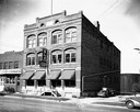
| Date: | 08 12 1931 |
|---|---|
| Description: | Fauerbach Brewery on the right, at 651-653 Williamson Street. Looking northeast along Williamson Street is the Madison Drug Co., 654 Williamson Street, Int... |
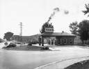
| Date: | 08 07 1929 |
|---|---|
| Description: | Bondi & Sachtjen Texaco service station, 1462 E. Washington Avenue at Thornton Avenue, with Fuller & Johnson buildings in the background. Text with print r... |
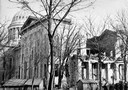
| Date: | 11 1883 |
|---|---|
| Description: | The ruins of the unfinished South Wing of the third Wisconsin State Capitol after its collapse while still under construction. |
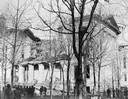
| Date: | 11 1883 |
|---|---|
| Description: | View of the third Wisconsin State Capitol showing the ruins of the South Wing addition after it collapsed during construction. |
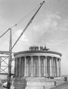
| Date: | 1909 |
|---|---|
| Description: | Workmen posing on the partially demolished dome of the third Wisconsin State Capitol, together with the hoist used for removing salvaged materials. This d... |
| Date: | 1920 |
|---|---|
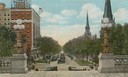
| Description: | Color illustration of a view from the Wisconsin State Capitol (which was the fourth State Capitol and the third in Madison) showing the Hotel Loraine and W... |
| Date: | 06 27 1935 |
|---|---|
| Description: | View across street towards the Calvary Lutheran University Church at 713 State Street. |
| Date: | 05 21 1933 |
|---|---|
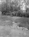
| Description: | Two men examine a break in the dike and the wash out damage at Forest Hill Cemetery, Section 22. The house in the background is located at 454 Virginia Ter... |

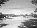
| Date: | 1958 |
|---|---|
| Description: | Aerial view of Craig Avenue and Crestwood Avenue. |
| Date: | 1958 |
|---|---|
| Description: | University of Wisconsin Eagle Heights. |
| Date: | 1958 |
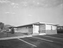
|---|---|
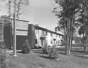
| Description: | Exterior of 27 Marshall Court, Doctors Park in Shorewood Hills. |
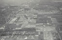
| Date: | 1958 |
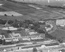
|---|---|
| Description: | Aerial photograph showing the J.S. Timlin Lumber Company, 2702 University Avenue, as well as Doctors Park, the Veterans Hospital, and the First Unitarian S... |
| Date: | 1958 |
|---|---|
| Description: | Marshall Court, Doctors Park and Shorewood Hills. |
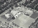
| Date: | |
|---|---|
| Description: | Aerial view of Our Lady Queen of Peace Church. |
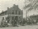
| Date: | 1900 |
|---|---|
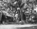
| Description: | Exterior view of Jefferson's Transfer Line, owned by Beverly Jefferson. Beverly Frederick Jefferson was the grandson of President Thomas Jefferson, being ... |
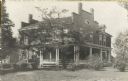
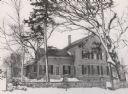
| Date: | 1914 |
|---|---|
| Description: | Exterior view of the residence of Mrs. M.S. Rowley on University Avenue, opposite the University of Wisconsin-Madison Chemistry building. |
If you didn't find the material you searched for, our Library Reference Staff can help.
Call our reference desk at 608-264-6535 or email us at: