 Filter: Categories of Wisconsin Historical Images
Filter: Subject of Dwellings
Filter: Subject of architecture
Filter: Year of 1800-1899
Filter: Categories of Wisconsin Historical Images
Filter: Subject of Dwellings
Filter: Subject of architecture
Filter: Year of 1800-1899
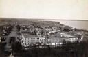
| Date: | 1885 |
|---|---|
| Description: | South Pinckney Street between East Washington Avenue (left) and King Street (right). On the right is the Marquette neighborhood. The large structure at the... |

| Date: | 1867 |
|---|---|
| Description: | Birds-eye drawing of Appleton, Outagamie Co., depicting street names and street layout, houses, the Fox River, the court house, jail, school houses, Lawren... |
| Date: | 1870 |
|---|---|
| Description: | Group of people posing outside of Soldiers' Orphans Home, located on Spaight Street between Paterson and Brearly Streets. The building was originally const... |
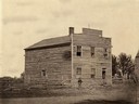
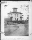
| Date: | 1870 |
|---|---|
| Description: | Council House of the first Wisconsin Territorial Legislature when it met at Belmont in 1836. A young boy or man wearing a hat stands in front near a fence. |
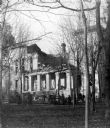
| Date: | 1883 |
|---|---|
| Description: | The third Wisconsin State Capitol after the unfinished South Wing collapsed on November 8, 1883. Defective workmanship and shoddy construction materials ca... |
| Date: | 1861 |
|---|---|
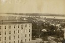
| Description: | View of Madison from Main Hall, now Bascom Hall, on the University of Wisconsin-Madison campus. South Hall is in the foreground, with several residences an... |
| Date: | 1861 |
|---|---|
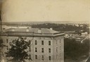
| Description: | View of Madison from Main Hall, now Bascom Hall, on the University of Wisconsin-Madison campus. South Hall is in the foreground with several residences an... |

| Date: | 1861 |
|---|---|
| Description: | View of Madison from Main Hall, now Bascom Hall, on the University of Wisconsin-Madison campus looking up State Street toward the second Wisconsin State Ca... |
| Date: | 1861 |
|---|---|
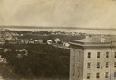
| Description: | View of Madison from Main Hall, now Bascom Hall, on the University of Wisconsin-Madison campus. North Hall is in the foreground with several residences and... |
| Date: | 11 11 1861 |
|---|---|
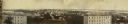
| Description: | Panoramic view of Madison from Main Hall, now Bascom Hall, on the University of Wisconsin campus. North Hall and South Hall are in the foreground. Lake Men... |
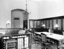
| Date: | 1893 |
|---|---|
| Description: | Office of the State Board of Control, Wisconsin Reformatory, Charitable and Penal Institutions in the third Wisconsin State Capitol. |
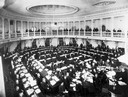
| Date: | 02 15 1899 |
|---|---|
| Description: | The Wisconsin State Assembly in session in the second Wisconsin State Capitol, with observers looking on from the gallery. |

| Date: | 1870 |
|---|---|
| Description: | Baraboo was first settled around 1838, and by 1870 it had become the county seat and the thriving village illustrated here. This birds eye drawing depicts ... |

| Date: | 1897 |
|---|---|
| Description: | A view from the capitol looking west up State Street toward the University of Wisconsin-Madison with the Holy Redeemer Church, Holy Redeemer School, Red Gy... |
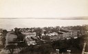
| Date: | 1890 |
|---|---|
| Description: | Looking south from the capitol dome of the Wisconsin State Capitol, the view is of West Main Street bound by South Hamilton Street and Monona Avenue (now M... |
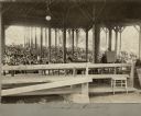
| Date: | 1886 |
|---|---|
| Description: | View from inside of the Monona Lake Assembly Meeting Pavilion looking out on a large crowd of people. |
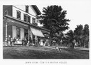
| Date: | 1885 |
|---|---|
| Description: | Illustration of people standing in front of the popular tourist resort Tonyawatha House from a book of two-tone lithograph views of Madison. About 1885 the... |
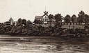
| Date: | 1885 |
|---|---|
| Description: | Illustration of the exterior of the tourist resort Tonyawatha Spring Hotel (an earlier version was called Tonyawatha House) from across Lake Monona. There ... |

| Date: | 1868 |
|---|---|
| Description: | This 1868 birds-eye view depicts the buildings, streets, railroad, vegetation and topography of Columbus, Wisconsin. The high school, cemetery, railroad de... |

| Date: | 1867 |
|---|---|
| Description: | Bird's-eye map of Green Bay and Fort Howard, Brown Co., depicts street names and street layouts, houses, trees, and the East River. A reference key at the ... |
If you didn't find the material you searched for, our Library Reference Staff can help.
Call our reference desk at 608-264-6535 or email us at: