 Filter: Categories of Wisconsin Historical Images
Filter: Subject of Exploration
Filter: Subject of arts
Filter: Categories of Wisconsin Historical Images
Filter: Subject of Exploration
Filter: Subject of arts

| Date: | 08 17 1965 |
|---|---|
| Description: | NBC News broadcaster Merrill Mueller interviewing Lockheed engineer Bud Zeller about the Gemini Agena Target Vehicle. The interview was part of a public re... |

| Date: | 08 13 1970 |
|---|---|
| Description: | Cover of "Chinook," an underground newspaper, featuring an ethereal drawing of a male hiker holding out a sign with an infinity symbol on it, as though he ... |
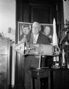
| Date: | 09 14 1962 |
|---|---|
| Description: | Senator Alexander Wiley posing with a cutaway model of an Apollo rocket. Behind him on a wall are portraits of Dwight D. Eisenhower and John F. Kennedy. |

| Date: | 1761 |
|---|---|
| Description: | This map shows the western hemisphere. Much of the north-west coast of North America is left blank, but the rest of the map lists the names of rivers, citi... |

| Date: | 1786 |
|---|---|
| Description: | This map is an updated version of d'Anville's 1761 map of the western hemisphere. He included more details to the north west coast of North America, partic... |

| Date: | 1710 |
|---|---|
| Description: | A seminal and fairly accurate map of the Great Lakes Region up to Baffin's Bay in Northern Canada. This is possibly the first printed map to locate Detroit... |

| Date: | 1715 |
|---|---|
| Description: | One of Herman Moll's most famous maps, often referred to as The Codfish Map, it shows rivers and portages, cities, Indian villages, wind directions, routes... |

| Date: | 1720 |
|---|---|
| Description: | This map of North America shows cities, rivers, lakes, and a few topographical features, complete with numerous descriptive blocks of text about expedition... |

| Date: | 1780 |
|---|---|
| Description: | This map shows the northern Pacific Ocean with North America and Asia, with cities and geographical features labeled, as well Russian, French and Spanish r... |

| Date: | 1755 |
|---|---|
| Description: | This map shows forts, missions, villages and cities, rivers and portages, and boundaries of the Spanish, English, and French territories, marking the large... |

| Date: | 1786 |
|---|---|
| Description: | One half of a four sheet nautical chart, showing the coastlines of the north-west hemisphere. The interior lands are left bare, even of basic features such... |

| Date: | 1775 |
|---|---|
| Description: | This map shows the northern Pacific Ocean along with north eastern Asia and western North America. The interior of Asia contains detailed engravings of pla... |

| Date: | 1790 |
|---|---|
| Description: | An updated and corrected version of Robert de Vaugondy's 1750 map "Amérique Septentrionale: Dressée sur les Relations les Plus Modernes des Voyageurs et Na... |

| Date: | 1696 |
|---|---|
| Description: | This sea chart and topographical map depicts the north east coast of Canada and North America, focusing on the Hudson Bay and Great Lakes regions. It shows... |

| Date: | 1783 |
|---|---|
| Description: | This map is hand-colored and shows the boundaries of British, Spanish, and the newly recognized American claims, as well as the fishing rights granted to F... |

| Date: | 1788 |
|---|---|
| Description: | This map shows the north western coast of North America, including the southern coast of what will be Alaska and parts of the Aleutian Islands. It includes... |
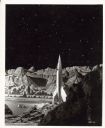
| Date: | |
|---|---|
| Description: | Still from the film 1950 film "Destination Moon." The rocket ship is sitting on the lunar landscape. |

| Date: | 1769 |
|---|---|
| Description: | Double hemispherical map showing the continents, islands, countries, and a few major cities of the world. The routes of a few explorers are depicted and la... |

| Date: | 1556 |
|---|---|
| Description: | One of the earliest obtainable maps to accurately (for its time) depict the Americas, this map shows more decorative than descriptive features. A few river... |

| Date: | 1675 |
|---|---|
| Description: | This atlas shows the western hemisphere, with a small portion of Spain and Africa. Several place names are labeled, such as the Plymouth colony, settlement... |
If you didn't find the material you searched for, our Library Reference Staff can help.
Call our reference desk at 608-264-6535 or email us at: