 Filter: Categories of Wisconsin Historical Images
Filter: Subject of Fields (Agriculture)
Filter: Subject of architecture
Filter: Subject of roads
Filter: Categories of Wisconsin Historical Images
Filter: Subject of Fields (Agriculture)
Filter: Subject of architecture
Filter: Subject of roads
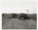
| Date: | 04 15 1934 |
|---|---|
| Description: | Onlookers surveying damage from a fatal two-car collision. The view is looking south on County Trunk Highway M, between Speedway Road and Middleton. In the... |

| Date: | |
|---|---|
| Description: | Advertising poster for International farm trucks and Farmall tractors. Features color illustrations of a K-1 truck and a Farmall H tractor. Includes the te... |

| Date: | 1878 |
|---|---|
| Description: | Bird's-eye map of Kewaskum. Includes a list of hotels, churches, post office, railroad depot, etc. |
| Date: | 03 04 1932 |
|---|---|
| Description: | Piper Brothers farm scene, 4718 Odana Road near Midvale. |
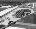
| Date: | 1947 |
|---|---|
| Description: | Aerial view of International Harvester's Evansville Works factory complex. |
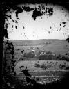
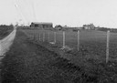
| Date: | 1873 |
|---|---|
| Description: | View of several farms, including Burton's, Fitlen's and Rustebakke's. Field arrangements and fencing patterns are evident. A man is walking along the bott... |
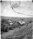
| Date: | |
|---|---|
| Description: | View from hill overlooking a farmstead at the base of the hill with a windmill and a pond. On the right in the foreground, two men, one sitting, one standi... |
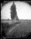
| Date: | |
|---|---|
| Description: | A rural lane lined with Lombardy poplars runs between two fenced fields. Two men are standing in the lane looking towards the camera. A church and many oth... |

| Date: | 1948 |
|---|---|
| Description: | Man sitting on a Farmall C tractor in front of a prototype International Harvester dealership. The man is talking with another man. Farm fields are in the ... |
| Date: | |
|---|---|
| Description: | Distant view of Waterbury mansion, with field, road and fencing in the foreground. |
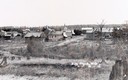
| Date: | 1900 |
|---|---|
| Description: | View from hill across field towards farmhouses, dwellings and churches along a road. In the foreground are stumps. Caption reads: "Big Falls, Wis." |

| Date: | 1905 |
|---|---|
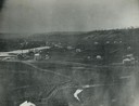
| Description: | Aerial view of town, with several large buildings along railroad tracks in the foreground, and fields and trees in the distance. Pedestrians are walking al... |

| Date: | 05 10 1928 |
|---|---|
| Description: | The Lutheran Church and buildings, seen from Lutheran Church Hill. |
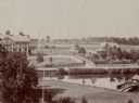
| Date: | 1860 |
|---|---|
| Description: | Elevated view of multiple buildings in Cross Plains from Lutheran Church Hill. Many roads and fences cross the fields. Wooded hills are in the background. ... |
| Date: | |
|---|---|
| Description: | Elevated view of barn and farmer's house of John Bass. |
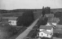
| Date: | 1908 |
|---|---|
| Description: | Elevated view of homes alongside a road in Hika (also known as Centerville). Handwritten on two of the buildings on the right are: "Ma's house." and "Louis... |

| Date: | 10 1928 |
|---|---|
| Description: | Aerial view of Sun Prairie, including the central business district, residences, and the surrounding countryside stretching to the horizon. |
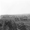
| Date: | 1912 |
|---|---|
| Description: | Elevated view of Wausau from the edge of town looking toward residences and businesses. Hills are in the far background. |
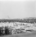
| Date: | 1912 |
|---|---|
| Description: | Winter view over fields of town with hills in the far background. |

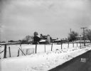
| Date: | 11 1951 |
|---|---|
| Description: | Aerial view of US Highway 14 southeast of La Crosse descending into Mormon Coulee. The original caption of the print, which is undated, describes the road ... |
If you didn't find the material you searched for, our Library Reference Staff can help.
Call our reference desk at 608-264-6535 or email us at: