 Filter: Categories of Wisconsin Historical Images
Filter: Subject of Fields (Agriculture)
Filter: Subject of rivers
Filter: Categories of Wisconsin Historical Images
Filter: Subject of Fields (Agriculture)
Filter: Subject of rivers

| Date: | |
|---|---|
| Description: | Elevated view from shoreline of a river with an iron bridge over it. Buildings are on the far shoreline near fields, and tree-covered hills are in the dist... |

| Date: | 03 1777 |
|---|---|
| Description: | Map showing the British and Hessian attack on Fort Washington in November of 1776. The movements and fortifications of the British and Hessian troops appea... |

| Date: | 1776 |
|---|---|
| Description: | Fairly detailed map of New York City and parts of Long Island. It shows streets, roads, wharves, ferries, ship yards, Fort George and the battery, public b... |
| Date: | |
|---|---|
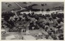
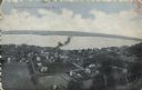
| Description: | Photographic postcard aerial view of Ettrick. A river is running through town. Dwellings and commercial buildings are surrounded by fields. |
| Date: | |
|---|---|
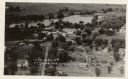
| Description: | Aerial view of Ettrick. A river and fields are in the background. There is a church in the foreground on the left, and on the main street are commercial bu... |

| Date: | 1993 |
|---|---|
| Description: | A small river winding through a farm field, with snow covering the banks and field. Trees and a house are on the horizon. |

| Date: | 1908 |
|---|---|
| Description: | Elevated view of Holcombe, with the dam on the Chippewa River in the foreground. Caption reads: "Birds-Eye View, Holcombe, Wis." |
| Date: | 07 1936 |
|---|---|
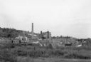
| Description: | View across field towards large smokestack towering above the complex of buildings at the Niagara paper mill. On the far right, water is flowing through th... |

| Date: | 1921 |
|---|---|
| Description: | View across field towards a bend in the Shullsburg Branch, which runs from the Galena River near the town of Lead Mine to the town of Shullsburg. A farm is... |

| Date: | 09 01 1919 |
|---|---|
| Description: | Photographic postcard view of a river, with part of an outbuilding in the foreground on the left. On the opposite shoreline is a farm, with farmhouse, barn... |

| Date: | |
|---|---|
| Description: | View from shoreline looking through fences towards a man standing in knee-deep water holding a net and scooping water into a bucket. Patches of land and tr... |
| Date: | |
|---|---|
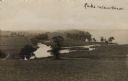
| Description: | View of Lake Waubesa from a hill. A farm is in the distance on the left. The Yahara River is in the foreground. Handwritten caption reads: "Lake Waubesa." |

| Date: | 1908 |
|---|---|
| Description: | Bird's-eye view showing Lake Mendota, Lake Monona, Lake Waubesa, Lake Wingra and Lake Kegonsa. Madison has only the isthmus developed, and there are settle... |

| Date: | 1928 |
|---|---|
| Description: | Birds-eye view showing Lake Mendota, Lake Monona, Lake Wingra, Lake Waubesa and Lake Kegonsa. Shows the growth of Madison from the Isthmus along the southe... |

| Date: | |
|---|---|
| Description: | View down hill where grassy fields lead down to the Yahara River where it meets Lake Waubesa. Two children are walking through the grass on the left. Capti... |
| Date: | 1950 |
|---|---|
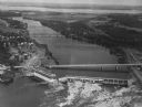
| Description: | Aerial view of a hydroelectric power plant owned by Northern States Power Company located on the Chippewa River. A highway bridge and a railroad bridge spa... |

| Date: | 01 05 1955 |
|---|---|
| Description: | Elevated view of two people breaking ice with an ax and an ice breaking pole [a gaff?]; other people in the background are standing in a boat pushing poles... |

| Date: | 1950 |
|---|---|
| Description: | Text on front reads: "Horseshoe Curve At Rock Springs, Wis." A road and a railroad track, with bridges over the Baraboo River, make a double curve in an el... |

| Date: | 1960 |
|---|---|
| Description: | Text on front reads: "Greetings from Spooner, Wis." Text on reverse: "Looking north on this aerial view one can see the State Fish Hatchery in the foregrou... |
| Date: | 05 19 1908 |
|---|---|
| Description: | Text on front reads: "Bird's-Eye View of Stockholm, Wis." A village in Pepin County, founded in 1854 by immigrants from Karlskoga, Sweden, who named it aft... |
If you didn't find the material you searched for, our Library Reference Staff can help.
Call our reference desk at 608-264-6535 or email us at: