Filter: Categories of Wisconsin Historical Images
Filter: Subject of Harbors
Filter: County of Milwaukee
Filter: Categories of Wisconsin Historical Images
Filter: Subject of Harbors
Filter: County of Milwaukee
| Date: | |
|---|---|
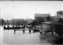
| Description: | Children gathered on fishing boats and piers in a harbor. |
| Date: | |
|---|---|
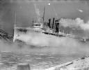
| Description: | An ice-covered car ferry, possibly docking in a harbor. |
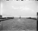
| Date: | 07 1899 |
|---|---|
| Description: | A boat leaving Milwaukee Harbor between two breakwaters, steaming into Milwaukee Bay and onward out into Lake Michigan. |
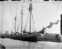
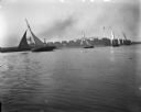
| Date: | 1898 |
|---|---|
| Description: | A large sailing ship docked in Milwaukee Harbor. |
| Date: | 1898 |
|---|---|
| Description: | Small sailboats in Milwaukee Harbor with buildings on the far shoreline in the background. There is a large sign on a roof that readsin part: "L.J. Petit..... |
| Date: | 01 20 1901 |
|---|---|
| Description: | A crowd gathers at Milwaukee Harbor standing on ice around the Julius Goll Jr. excursion boat. |
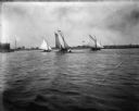
| Date: | 1898 |
|---|---|
| Description: | Four sailboats in Milwaukee Harbor, one of which, The Kim, has Syl on board. In the background are railroad cars and industrial buildings. |
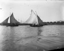
| Date: | 1898 |
|---|---|
| Description: | View across water of sailboats in Milwaukee Bay. One of the boats, The Kim, has Syl on board. In the background are industrial buildings, one of whi... |
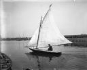
| Date: | 1898 |
|---|---|
| Description: | Pennyfeather sitting in a small sailboat in Milwaukee Harbor. There are industrial buildings on the far shoreline, and other boats at anchor in the backgro... |

| Date: | 1936 |
|---|---|
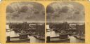
| Description: | An elevated view of Milwaukee Harbor with railroad station looking towards Lake Michigan. |

| Date: | 05 1958 |
|---|---|
| Description: | Photocopy of a map created by the City of Milwaukee Master Plan Program City Planning Division in May of 1958 representing 1870 "THE CENTRAL AREA OF THE CI... |

| Date: | 1836 |
|---|---|
| Description: | This map is pen-and-ink on paper and shows marshlands, rivers, creeks, a quarry, and a few roads. |

| Date: | 1848 |
|---|---|
| Description: | Pen-and-ink on paper. The title of the map is inscribed on the back. The map shows buildings, roads, marshes, wild rice, piles and docks, deep water, and o... |

| Date: | 1951 |
|---|---|
| Description: | This map is a survey of Lake Michigan and the section of Milwaukee that borders the lake. Map of land includes major streets, and landmarks near water. Rel... |

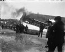
| Date: | 07 25 1967 |
|---|---|
| Description: | Newspaper caption reads: "Passersby don't know it, but what appears to be a coonskin cap around the neck of Todd Vasas, 16, of 2773 S. Shore Drive, is the ... |

| Date: | 1907 |
|---|---|
| Description: | This map is a chart of Milwaukee Harbor that displays local streets, bridges, roads, railroads, public buildings, businesses, factories, dry docks, parks, ... |

| Date: | 1854 |
|---|---|
| Description: | This map shows bay and harbor soundings, the Milwaukee River, and select buildings. Depths are shown by soundings and relief is shown by hachures. The top ... |
| Date: | 1854 |
|---|---|
| Description: | This map is oriented with north slightly to the right and the Milwaukee River is labeled. The top margin reads: "Senate Ex. Doc. No. 1. 1st Session, 33rd C... |

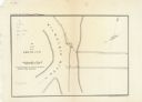
| Date: | 10 13 1864 |
|---|---|
| Description: | This map shows the shore line of Oct. 14 1864, city limits of water lots, and the elevation of water in Lake Michigan. Depths are shown by soundings. |
If you didn't find the material you searched for, our Library Reference Staff can help.
Call our reference desk at 608-264-6535 or email us at: