 Filter: Categories of Wisconsin Historical Images
Filter: Subject of Land companies
Filter: Categories of Wisconsin Historical Images
Filter: Subject of Land companies

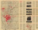
| Date: | 1911 |
|---|---|
| Description: | This map of Polk County, Wisconsin, from the early 20th century shows the land for sale by the Baker Land and Title Co. of Saint Croix Falls. The township ... |

| Date: | 1914 |
|---|---|
| Description: | This map of Price County, Wisconsin, from the early 20th century shows land for sale by the Homemaker Land Company of Milwaukee. The township and range sys... |

| Date: | 1903 |
|---|---|
| Description: | This map of Richland County, Wisconsin, shows land ownership and acreages, the township and range grid, sections, cities, towns and post offices, roads, ra... |
| Date: | 1907 |
|---|---|
| Description: | "Lands colored in red owned and for sale by J.L. Gates Land Company, Milwaukee, Wis." Also shows wagon roads, railroads, schools, and settlers. On verso: M... |

| Date: | 1910 |
|---|---|
| Description: | Shows land for sale by Rusk Farm Co. in Rusk and Chippewa Counties, as well as farmhouses, roads, and railroads. |
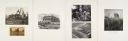
| Date: | |
|---|---|
| Description: | Even the slow, dry, hungry engines, digging what would be the best of times, cannot help but leave behind them a restlessness unchanging as bef... |
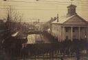
| Date: | 12 18 1890 |
|---|---|
| Description: | Elevated view looking down at homestead applicants waiting in line for 2-3 days in winter cold before a window in the Marathon County Court House, Dec. 18-... |

| Date: | 1836 |
|---|---|
| Description: | This map of Belmont includes notarization from the justice of the peace of Iowa County, May 15, 1836, acknowledging John Atchison as proprietor of Belmont ... |
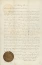
| Date: | 04 12 1877 |
|---|---|
| Description: | Document granting a parcel of land to the Wisconsin Railroad Farm Mortgage Land Company signed by Secretary of State, Peter Doyle. The document bears the o... |

| Date: | |
|---|---|
| Description: | Postcard advertising the Good Land Company with a photograph of a farm and information for "Homeseekers, Farmers and Investors." |
| Date: | 04 1848 |
|---|---|
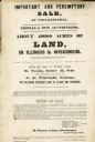
| Description: | Poster advertising an auction for about 49,000 acres of land for sale in Wisconsin and Illinois by Thomas & Sons Auctioneers. |
| Date: | 1855 |
|---|---|
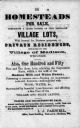
| Description: | Poster advertising homesteads and village lots for sale. |

| Date: | 1874 |
|---|---|
| Description: | This map shows townships and sections, post offices, roads, and railroads. The left margin reads: "For sale at Cushing Land Agency, St. Croix Falls, Wis. 4... |

| Date: | 1845 |
|---|---|
| Description: | This map shows lakes, rivers, Chippewa land, the U.S. Mineral Land Agency, boundary between U.S. and Canada, Methodist and Catholic missions, and American ... |

| Date: | 1891 |
|---|---|
| Description: | This blueprint manuscript map shows land owned by Green Bay & Mississippi Canal Co., Meade, Vilas, Patten, and Hewitt. Streets and the Fox River are labele... |
| Date: | 1900 |
|---|---|
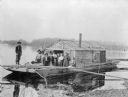
| Description: | Group of people on a wanigan, the "Dancing Annie," used by Chippewa Lumber and Supply Company near Eagle Rapids. A wanigan is a floating office and supply ... |

| Date: | 1912 |
|---|---|
| Description: | Marinette County, Township 36 N., Range 19 E. |

| Date: | 1912 |
|---|---|
| Description: | Marinette plat map, Township 37 N., Range 19 E. |

| Date: | 1912 |
|---|---|
| Description: | Marinette County, Township 36 N., Range 20 E. |
If you didn't find the material you searched for, our Library Reference Staff can help.
Call our reference desk at 608-264-6535 or email us at:
