 Filter: Categories of Wisconsin Historical Images
Filter: Subject of Maps
Filter: Creator Name of Unknown
Filter: Categories of Wisconsin Historical Images
Filter: Subject of Maps
Filter: Creator Name of Unknown

| Date: | 1800 |
|---|---|
| Description: | Map of the United States. It shows the states, including Tennessee, cities, towns, Native American land, mountains, lakes, and rivers. Lead mines appear ju... |

| Date: | 1781 |
|---|---|
| Description: | Map of New Hampshire and surrounding regions. It shows borders, regions, cities, numerous forts, the country of the Iroquois, mountains, rivers, and lakes.... |

| Date: | 1755 |
|---|---|
| Description: | Map of New England, with three inset maps of Fort Oswego, Fort du Quesne, and Fort Frederick. It shows colonies, a few cities, forts (marked as French or E... |

| Date: | 1775 |
|---|---|
| Description: | Map of Boston and surrounding regions, from Massachusetts Bay to the Connecticut River, and including part of southern New Hampshire. It shows the colonies... |

| Date: | 1780 |
|---|---|
| Description: | Map of eastern Massachusetts, Rhode Island, eastern Connecticut, and small portions of New Hampshire and Vermont. It shows the boundaries, counties, citie... |

| Date: | 1780 |
|---|---|
| Description: | Map of Connecticut, Rhode Island, and Long Island. it shows the borders, cities, roads, islands, mountains, lakes and rivers. Navigational hazards along th... |

| Date: | 06 26 1919 |
|---|---|
| Description: | Map outlining Alfred Lawson's plan for airmail delivery routes across the United States, including several stops in Wisconsin. The accompanying text reads:... |

| Date: | 1937 |
|---|---|
| Description: | Map showing territory controlled by the Finches, a family of bandits who terrorized south central Wisconsin in the years prior to the Civil War. The map in... |

| Date: | |
|---|---|
| Description: | Drawing of a map showing the cruise routes from Eagle Inn Dock and the points of interest. There is a schedule and rates on the reverse. |
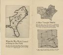
| Date: | 11 1918 |
|---|---|
| Description: | Three maps showing areas in which the War Work Council did some work. |
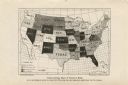
| Date: | 1915 |
|---|---|
| Description: | Map showing each state's work hour limitations for women. |
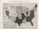
| Date: | 03 23 1912 |
|---|---|
| Description: | A map showing proportions of women's suffrage in the United States. |
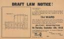
| Date: | 09 03 1918 |
|---|---|
| Description: | Poster providing information about draft registration in the twenty-third district of Milwaukee. Includes map of the district showing precinct boundaries a... |

| Date: | 1918 |
|---|---|
| Description: | Poster featuring a map of the near East, with countries demarcated. The poster title is red text reading: "Where the Victims Are." The rest of the text rea... |

| Date: | 11 1964 |
|---|---|
| Description: | Fold-out map of the zoo inside a publication titled: "Henry Vilas Park Zoo: An Instructive Book on the Origin and Habits of Animals." Includes Lake Wingra,... |

| Date: | 1918 |
|---|---|
| Description: | Poster featuring a map of "Central Europe" and its annexes in the Near East (Germany, Austria-Hungary, Bulgaria, Turkey), territory occupied or controlled ... |
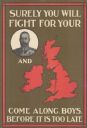
| Date: | 1915 |
|---|---|
| Description: | British poster with a circular framed portrait of the king dressed in a military uniform, and a red map of the United Kingdom. Text reads: "Surely You Will... |

| Date: | 1925 |
|---|---|
| Description: | Map of northern Africa with the border between Algeria and Tunisia drawn in red. Caption reads: "199A — (L61208) Map Series 2 The Eastern Barbary States." |

| Date: | 1865 |
|---|---|
| Description: | Portrait of Reverend Edward Mathews standing in front of a "Moral Map of the United States." He is holding a long, wooden pointer and is gesturing towards ... |
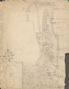
| Date: | 1929 |
|---|---|
| Description: | An unsigned, hand-drawn map of properties owned by members of the Brumder family on the northwest shore of Pine Lake in 1929. Named Villa Henrietta, the pr... |
If you didn't find the material you searched for, our Library Reference Staff can help.
Call our reference desk at 608-264-6535 or email us at: