 Filter: Categories of Wisconsin Historical Images
Filter: Subject of Menominee Indians
Filter: Year of 1900-1999
Filter: Categories of Wisconsin Historical Images
Filter: Subject of Menominee Indians
Filter: Year of 1900-1999

| Date: | 1975 |
|---|---|
| Description: | Actor Marlon Brando (center) and Father James Groppi of Milwaukee arrive at the Alexian Novitiate in Gresham. The building had been seized by members of th... |
| Date: | 01 18 1975 |
|---|---|
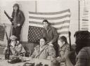
| Description: | Negotiations between leaders of the Menominee Warrior Society and the American Indian Movement with General Hugh Simonson (in the Army jacket) of the Wisco... |
| Date: | 1975 |
|---|---|
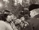
| Description: | Negotiations between Neil Hawpetoss, a leader of the Menominee Warrior Society that had seized the Alexian Novitiate at Gresham in January 1975, and a memb... |
| Date: | 1975 |
|---|---|
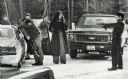
| Description: | An unidentified member of the Wisconsin State Patrol points his revolver at several Native Americans at a vehicle checkpoint near Gresham. The State Patrol... |

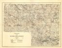
| Date: | 1938 |
|---|---|
| Description: | This map shows lakes, rivers, roads, trails, lookout towers, and railroads. |

| Date: | 1979 |
|---|---|
| Description: | A map of Southern Wisconsin and northern Illinois showing the areas inhabited by the Ho-Chuck, formerly known as the Winnebago. Some of the location names ... |
| Date: | 05 25 1956 |
|---|---|
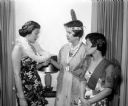
| Description: | Attending the YWCA Benefit Tea for internationally speaking foreign students in costume of their native land are, left to right: Judith Ahana, Honolulu Haw... |

| Date: | 1941 |
|---|---|
| Description: | Wisconsin counties, towns, cities, and selected villages, as well as the Menominee Indian Reservation are identified on this U.S. Bureau of the Census map ... |

| Date: | 1952 |
|---|---|
| Description: | This map shows counties, towns, cities, and selected villages, as well as the Menominee Indian Reservation are identified on this U.S. Post Office. Circles... |

| Date: | 1900 |
|---|---|
| Description: | This map of shows the township grid, counties, cities and villages, lakes, rivers, rail lines and the Menominee Indian Reservation. |

| Date: | 1902 |
|---|---|
| Description: | This map shows the railroads of southern Wisconsin with the routes of the Chicago, Milwaukee, and St. Paul Railway traced in red. The township grid, counti... |

| Date: | 1910 |
|---|---|
| Description: | This map of northeastern Wisconsin shows the township grid, counties, cities and villages, lakes, rivers, rail lines and the Menominee Indian Reservation. ... |

| Date: | 09 17 1959 |
|---|---|
| Description: | A map of the Menominee Indian Reservation that shows the highways, different types of roads, rivers and streams in the area. |

| Date: | 1993 |
|---|---|
| Description: | A series of three maps showing the lands of the Menominee, the first of these three maps shows the present-day Menominee Indian Reservation. Highways and r... |

| Date: | 1933 |
|---|---|
| Description: | This map shows the township and range system, sections, cities and villages, schools, roads, railroads, and lakes and streams in Shawano County, which at t... |

| Date: | 1958 |
|---|---|
| Description: | Portrait of Menoninee Indian performer in full dress seated for waist-up portrait. Member of the Peavey Falls group of dancers and musicians from the Menom... |

| Date: | 1958 |
|---|---|
| Description: | Image is an outdoor portrait of a performer wearing a fringed vest, beaded necklace and headdress, and holding a small axe. Member of the Peavey Falls grou... |

| Date: | 1958 |
|---|---|
| Description: | The image shows a performer standing and holding a pipe. Member of the Peavey Falls group of dancers and musicians from the Menominee Indian Reservation in... |

| Date: | 1958 |
|---|---|
| Description: | Four generations of men and boys pose for a portrait of Menoninee Indians in full dress standing outdoors near a gate and fence. A sign says: "Indian Vill... |
| Date: | 1929 |
|---|---|
| Description: | Map of the Menominee Indian Reservation. Legend reads: "Topographic and cultural data were obtained from field notes of a timber cruise and land classifica... |
If you didn't find the material you searched for, our Library Reference Staff can help.
Call our reference desk at 608-264-6535 or email us at: