 Filter: Categories of Wisconsin Historical Images
Filter: Subject of Michigan, Lake
Filter: Subject of streams
Filter: Categories of Wisconsin Historical Images
Filter: Subject of Michigan, Lake
Filter: Subject of streams

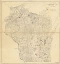
| Date: | 1874 |
|---|---|
| Description: | This map shows lakes, rivers, state, county, and town boundaries, as well as railroads completed, in progress, and contemplated. The map includes a color d... |

| Date: | 1918 |
|---|---|
| Description: | Map of Wisconsin along with the western portion of Michigan’s Upper Peninsula, showing county lines, cities and villages, lakes, streams, and railroads. Po... |

| Date: | 1917 |
|---|---|
| Description: | A geological survey map of southeastern Wisconsin that shows the configuration of the bedrock beneath the glacial drift and other deposits in southeastern ... |

| Date: | 1917 |
|---|---|
| Description: | A geological survey map that map of southeastern Wisconsin shows the surface deposits east of the Wisconsin River, from the Illinois state line north to Ne... |
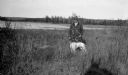
| Date: | 1923 |
|---|---|
| Description: | A well-dressed man poses holding a German short-haired pointer on a leash near the outlet of the Fish Creek into the harbor. |
| Date: | 12 01 1935 |
|---|---|
| Description: | This Wisconsin Public Service Commission map shows the lakes and streams of Wisconsin. |
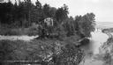
| Date: | 1915 |
|---|---|
| Description: | Elevated view of a two-story house sited beside Shivering Sands Creek where it enters Lake Michigan. There is a rustic footbridge over the stream close to ... |
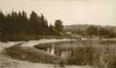
| Date: | 1920 |
|---|---|
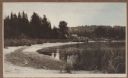
| Description: | View along shoreline towards a rustic foot bridge which crosses the mouth of Fish Creek, which separates the village of Fish Creek from Peninsula State Par... |

| Date: | 1946 |
|---|---|
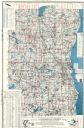
| Description: | A map showing the roads, railroads, towns, cities and villages, streams and lakes, airports, schools, churches, cemeteries, and golf courses in Kenosha Cou... |

| Date: | |
|---|---|
| Description: | A hand-drawn Geological map of the Upper Peninsula of Michigan, showing the counties and streams of that area. The map also identifies the location of the... |

| Date: | 1858 |
|---|---|
| Description: | An ink on paper map of Milwaukee County and the eastern portion of Waukesha County that shows the townships of Oak Creek, Franklin, Greenfield, Wauwatosa, ... |

| Date: | 1837 |
|---|---|
| Description: | A pen and ink on tracing paper, hand-drawn and colored map the proposed route of the Milwaukee and Rock River Canal, ranging from the Rock River in the wes... |

| Date: | 1838 |
|---|---|
| Description: | A map of the proposed route of the Milwaukee and Rock River Canal from Fort Atkinson on the Rock River in the west to the city of Milwaukee and Lake Michig... |

| Date: | 1886 |
|---|---|
| Description: | This map, originally published in the 1881 Illustrated historical atlas of Wisconsin, shows the township and range system, sections,towns, cities and villa... |

| Date: | 1934 |
|---|---|
| Description: | This 1930s highway map of Sheboygan County, Wisconsin, shows roads, the township and range grid, towns, sections, cities and villages, and streams, lakes, ... |

| Date: | 10 19 1836 |
|---|---|
| Description: | This 1836 manuscript map shows the sections, windfalls, marshes, streams, prairies, acreages, and former mouth of the Pike River in what is now the eastern... |
| Date: | 1915 |
|---|---|
| Description: | A rustic foot bridge over Fish Creek connects Peninsula State Park (foreground) with the village of Fish Creek. The Vits house is at the right end of the b... |

| Date: | 1987 |
|---|---|
| Description: | This 1987 map of Door County, Wisconsin, shows streets and roads, cities and villages, state parks, lakes and streams, and depths in Lake Michigan. A stree... |

| Date: | 1903 |
|---|---|
| Description: | Map shows railroads, roads, street car lines, schools, churches, cemeteries, town halls, and railroad stations. Includes inset lists of: Population of Milw... |
| Date: | 1960 |
|---|---|
| Description: | This map shows lakes arranged by county, depth maps of selected larger lakes, and enlargements of Mississippi River areas. The map also includes locations ... |
If you didn't find the material you searched for, our Library Reference Staff can help.
Call our reference desk at 608-264-6535 or email us at: