 Filter: Categories of Wisconsin Historical Images
Filter: Subject of Military bases
Filter: Subject of shorelines
Filter: Categories of Wisconsin Historical Images
Filter: Subject of Military bases
Filter: Subject of shorelines

| Date: | 1851 |
|---|---|
| Description: | A rare photograph of U.S. Army soldiers stationed at Fort Howard rowing a boat on the Fox River. Fort Howard, built in 1816, was the first in the chain of ... |

| Date: | 1851 |
|---|---|
| Description: | View of five soldiers rowing in a boat, beside a dock, with another soldier standing on the dock. The fort is in the background, complete with the fortifie... |

| Date: | 1851 |
|---|---|
| Description: | Several men rowing in a boat near Fort Howard that has an American Flag, barracks, and various related military buildings enclosed behind a wall. |

| Date: | 1814 |
|---|---|
| Description: | Fort Shelby, built by the Americans during the War of 1812. In 1814 the fort surrendered to British forces led by Captain Andrew W. Bulger who renamed it F... |
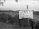
| Date: | 1942 |
|---|---|
| Description: | A soldier walks along the edge of a cliff in Panama, behind stacks of cannonballs and a large sign. The man is wearing a uniform and is holding a sub-machi... |
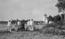
| Date: | 1915 |
|---|---|
| Description: | Six Coastguardsmen pose with an officer on the shore at the Coast Guard Station at Baileys Harbor. The men are identified as (left to right) Reinhart Hicke... |
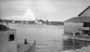
| Date: | 1915 |
|---|---|
| Description: | The Baileys Harbor Coast Guard Life Saving Station viewed from between a fishing boat and a pier warehouse. The station's pier extends into the harbor and ... |
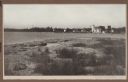
| Date: | 1915 |
|---|---|
| Description: | View from shoreline over water towards the Coast Guard Station and houses at Baileys Harbor. The long pier extending from the station's boathouse is easily... |

| Date: | 02 05 1944 |
|---|---|
| Description: | General view of Port Moresby Harbor from road, New Guinea (present day Papua New Guinea). A jeep is on the road on the left. Several soldiers are near a sh... |
| Date: | 02 05 1944 |
|---|---|
| Description: | View from road of the exterior of the Allied Officers' Club in Port Moresby, New Guinea (present day Papua New Guinea). It is built on posts above the wate... |
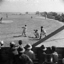
| Date: | 02 22 1945 |
|---|---|
| Description: | The batter swings at an exhibition baseball game on a Naval Base on Kwajalein Island of the Marshall Islands in the South Pacific. Both teams had Big Leagu... |

| Date: | 10 1776 |
|---|---|
| Description: | Broadside map showing the British invasion of New York city in August and September of 1776. The map shows important cities, forts, roads, hills, mountains... |

| Date: | 1781 |
|---|---|
| Description: | Map of North and South Carolina and Virginia towards the end of the Revolutionary War. It shows borders, counties, cities, court houses, bridges, chapels, ... |

| Date: | 1781 |
|---|---|
| Description: | Map of the southern portion of the Chesapeake Bay and surrounding lands. It shows counties, a few cities and towns, forts, roads, islands, topographical fe... |

| Date: | 1793 |
|---|---|
| Description: | Detailed topographical map of the Ohio River between Clarkville and Louisville. It shows plots of farmland, forest, islands, garden plots, houses, Fort Fe... |

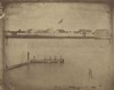
| Date: | 1851 |
|---|---|
| Description: | Elevated view across water towards Fort Howard. In the foreground is a man standing on a pier, and in the water nearby are five men rowing in a boat. Capti... |
| Date: | 1851 |
|---|---|
| Description: | A rare photograph of U.S. Army soldiers stationed at Fort Howard rowing a boat on the Fox River. Fort Howard, built in 1816, was the first in the chain of ... |
If you didn't find the material you searched for, our Library Reference Staff can help.
Call our reference desk at 608-264-6535 or email us at: