 Filter: Categories of Wisconsin Historical Images
Filter: Subject of Ocean
Filter: Subject of land
Filter: Categories of Wisconsin Historical Images
Filter: Subject of Ocean
Filter: Subject of land

| Date: | 1950 |
|---|---|
| Description: | Export map for International Harvester products manufactured in Australia at the company's Geelong and Dandenong Works. |
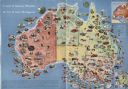
| Date: | 1950 |
|---|---|
| Description: | Color illustrated map of Australia shows various resources available in the different regions of Australia. Original caption: "Australia is the the mi... |

| Date: | |
|---|---|
| Description: | Three-quarter view from front of passenger side of Scout parked on beach. The Scout has a windshield and roll bars in place, but no doors. The ocean is in ... |

| Date: | |
|---|---|
| Description: | Passenger side view of Scout parked on beach. The Scout has a windshield and roll bars in place, but no doors. The ocean is in the background. |

| Date: | |
|---|---|
| Description: | Passenger side view of Scout parked on dunes. The Scout has a windshield and roll bars in place, but no doors. The ocean is in the background. |

| Date: | |
|---|---|
| Description: | Three-quarter view from front of driver's side of Scout parked on beach. The Scout has a windshield and roll bars in place, but no doors. The ocean is in t... |

| Date: | |
|---|---|
| Description: | Three-quarter view from front of driver's side of Scout parked on beach. The Scout has a windshield and roll bars in place, but no doors. The ocean is in t... |

| Date: | |
|---|---|
| Description: | Driver's side view of Scout parked on beach. The Scout has a windshield and roll bars in place, but no doors. A white helmet is sitting on the driver's sea... |

| Date: | 1968 |
|---|---|
| Description: | Three-quarter view from front of passenger side of red International Scout with white Traveltop. Two people are in the front seat. The sides of the Travelt... |

| Date: | 1868 |
|---|---|
| Description: | This map is one of the earliest weather maps of the United States, which traced an 1859 storm across the continent. Manuscript annotations in red ink show ... |

| Date: | 1895 |
|---|---|
| Description: | Map showing the continents of the world with the Americas at the center. From left to right land masses names are: "Siberia, Chinese Empire, Australia, Nor... |

| Date: | 1950 |
|---|---|
| Description: | Inside spread illustration of the world, with a legend indicating: Subsidiary Company, Branch of Subsidiary, Representative, Works, and Distributor. |

| Date: | 1942 |
|---|---|
| Description: | This pictorial bird's-eye-view map shows the United States of America with parts of Canada and Mexico. Landscape, trade, industry, points of interest, peop... |

| Date: | 1946 |
|---|---|
| Description: | This map shows scenes from America's history with names of historical events superimposed on a map of the United States. |
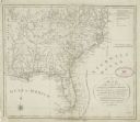
| Date: | 1792 |
|---|---|
| Description: | This map depicts the fixed boundaries by a peace treaty between the United States and the Spanish Dominions. |
| Date: | |
|---|---|
| Description: | Watercolor painting of a sailing ship on a sea or ocean. A large rock formation is on the left. |

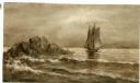
| Date: | 1878 |
|---|---|
| Description: | This lithograph shows Greenland, North America, Central America, South America, Polynesia, Australia, the Pacific Ocean, the Atlantic Ocean, the Arctic Oce... |

| Date: | 1878 |
|---|---|
| Description: | This lithograph shows Africa, Europe, Asia, Australia, and the Antarctic Continent, the Atlantic Ocean, the Indian Ocean, the Arctic Ocean, the Pacific Oce... |

| Date: | 1761 |
|---|---|
| Description: | This map shows the western hemisphere. Much of the north-west coast of North America is left blank, but the rest of the map lists the names of rivers, citi... |

| Date: | 1786 |
|---|---|
| Description: | This map is an updated version of d'Anville's 1761 map of the western hemisphere. He included more details to the north west coast of North America, partic... |
If you didn't find the material you searched for, our Library Reference Staff can help.
Call our reference desk at 608-264-6535 or email us at: