 Filter: Categories of Wisconsin Historical Images
Filter: Subject of Ocean
Filter: Subject of land
Filter: Year of 1700-1799
Filter: Categories of Wisconsin Historical Images
Filter: Subject of Ocean
Filter: Subject of land
Filter: Year of 1700-1799

| Date: | 1784 |
|---|---|
| Description: | Plate 57. Scene from Cook's Third Expedition, 1776-1779, while in Alaska. |

| Date: | 1780 |
|---|---|
| Description: | Contenant: New Hampshire, Massachusetsbaye, Rhode Island, Connecticut, La Nouvelle York, Nouvelle Jersey, La Pensilvanie, Les Comtes de Newcastle, Kent et ... |

| Date: | 1798 |
|---|---|
| Description: | Uncolored. No scale. One of the earliest maps to show the proposed division of the northwest territory into states. |

| Date: | 1755 |
|---|---|
| Description: | From "A map of the British and French dominions in North American with the roads, distances, limits, and extent of the settlements". |

| Date: | 1772 |
|---|---|
| Description: | Scale: about 180 miles to 1 in. |

| Date: | 1755 |
|---|---|
| Description: | Color map of North American territories owned by the English and by the French. Scale: about 115 milles d'Angleterre to 1 inch. French title is "Carte des ... |

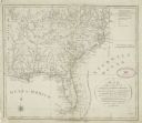
| Date: | 1784 |
|---|---|
| Description: | Map of The United States of America according to the Treaty of Peace of 1784. |

| Date: | 1744 |
|---|---|
| Description: | Paris: 1744. W 92⁰--W 76⁰/N 49⁰--N 41⁰. Scale [ca. 1:4,000,000] |

| Date: | 1778 |
|---|---|
| Description: | This Italian map from 1778 depicts the upper portion of the Old Northwest. Rivers and lakes are identified and relief, real and imagined, is depicted picto... |

| Date: | 1720 |
|---|---|
| Description: | Double hemispherical world map showing routes of Tasman, Magellan, Mendana, etc. Relief shown pictorially. Title in oak wreath cartouche. Map between four ... |

| Date: | 1740 |
|---|---|
| Description: | From Weigel's Atlas portatilis, oder, Compendieuse Vorstellung der gantzen Welt. Map of Europe. |

| Date: | 1712 |
|---|---|
| Description: | Engraved double-hemispherical world map by Moll, included in his atlas The world described, or, A new and correct sett of maps: shewing the kingdoms and st... |

| Date: | 1798 |
|---|---|
| Description: | Engraved and hand-colored map of Egypt. Map title appears on bottom left as a carving in stone next ... |

| Date: | 1740 |
|---|---|
| Description: | Engraved and hand-colored map of the Iberian peninsula as a theater of war during the War of the Spanish Succession (1701-1714). The map is dedicated to Ki... |

| Date: | 1785 |
|---|---|
| Description: | Map of part of North America engraved and hand-colored (the light brown design is a superposition of the map and cartouche derived from the oxidation of th... |

| Date: | 02 01 1793 |
|---|---|
| Description: | Text in the upper right corner reads, "A Map of The Western Part of the Territories belonging to the United States of America. Drawn from the best authorit... |
| Date: | 1792 |
|---|---|
| Description: | This map depicts the fixed boundaries by a peace treaty between the United States and the Spanish Dominions. |

| Date: | 1761 |
|---|---|
| Description: | This map shows the western hemisphere. Much of the north-west coast of North America is left blank, but the rest of the map lists the names of rivers, citi... |

| Date: | 1786 |
|---|---|
| Description: | This map is an updated version of d'Anville's 1761 map of the western hemisphere. He included more details to the north west coast of North America, partic... |

| Date: | 1746 |
|---|---|
| Description: | Map of North America from the southern portion of James Bay to Florida. It shows the colonies, cities, Native American land, and topological and geographic... |
If you didn't find the material you searched for, our Library Reference Staff can help.
Call our reference desk at 608-264-6535 or email us at: