Filter: Categories of Wisconsin Historical Images
Filter: Subject of Railroads
Filter: County of Dane
Filter: Subject of architecture
Filter: Categories of Wisconsin Historical Images
Filter: Subject of Railroads
Filter: County of Dane
Filter: Subject of architecture
| Date: | 1873 |
|---|---|
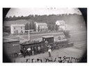
| Description: | Elevated view of several men, some of whom may be railroad workers, posing in front of a Minnesota and St. Paul wood-burning engine at a train crossing. Th... |

| Date: | 1908 |
|---|---|
| Description: | Colored map showing a panoramic view of Madison in great detail. The Wisconsin State Capitol is located at the center, with Lake Mendota in the background ... |
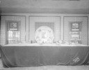
| Date: | 05 15 1943 |
|---|---|
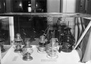
| Description: | Wisconsin Historical Society museum display of railroad lanterns in the "Building Wisconsin Railroads" exhibit. |
| Date: | 10 24 1935 |
|---|---|
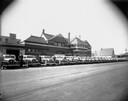
| Description: | Line up of City Cabs in front of the J. Heilprin & Co. Wholesale Fruits & Groceries, 612 W. Main Street, formerly the Illinois Central Passenger Depot. |
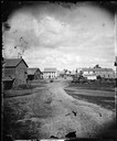
| Date: | 1874 |
|---|---|
| Description: | View looking southwest down the 600 block of Williamson Street to the East Madison Passenger Depot of the Chicago & Northwestern Railroad. There are frame ... |

| Date: | 1867 |
|---|---|
| Description: | Bird's-eye map of Madison with insets of the University, Rasdall House, Vilas House, and the Wisconsin State Capitol. View includes cattail marsh, smokesta... |

| Date: | 1885 |
|---|---|
| Description: | Bird's-eye map of Madison, State Capital of Wisconsin, County Seat of Dane County, with inset of the Wisconsin State Capitol. |

| Date: | 1942 |
|---|---|
| Description: | Aerial view of Oscar Mayer & Company, 910 Mayer Avenue at Packers Avenue. Shows stock yards, railroad cars and automobile parking lot. Also shows C.E. & P.... |
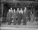
| Date: | 12 22 1930 |
|---|---|
| Description: | Phil La Follette confers with rail chiefs. Front row (left-right): F.B. Seymour, Green Bay and Western, Philip F. La Follette, Governor-elect, Fred W. Sarg... |
| Date: | 09 29 1930 |
|---|---|
| Description: | Display in RKO Capitol Theatre's outer lobby for "Danger Lights" and coming attraction "Africa Speaks." Features a model train from Wolff-Kubly & Hersig, w... |

| Date: | 1855 |
|---|---|
| Description: | Part of George Harrison's "Map of the City of Madison," showing the development of the isthmus and the small size of the second Capitol (54' x 104') in com... |
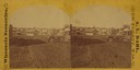
| Date: | 1869 |
|---|---|
| Description: | View from across the railroad track. The Milwaukee and St. Paul Railroad car #4770 is in the foreground. The Freeman House, Carlisle House and Empire Stove... |

| Date: | 1938 |
|---|---|
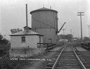
| Description: | The Crown Can Company, along the Chicago & Northwestern Railroad line. |

| Date: | 1855 |
|---|---|
| Description: | Map of the city of Madison, Dane County, published by George Harrison, surveyed and drawn by P. McCabe, and engraved by J.H. Colton & Co., New York. In add... |
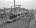
| Date: | 11 20 1945 |
|---|---|
| Description: | Madison-Kipp Corporation, 201 Waubesa Street, beside the Chicago, Milwaukee, St. Paul and Pacific railroad tracks. Shown are three loaded flatcars on a si... |

| Date: | 02 09 1949 |
|---|---|
| Description: | Aerial view of Madison, looking east across the Isthmus including the Wisconsin State Capitol, Lake Mendota, and Lake Monona. |
If you didn't find the material you searched for, our Library Reference Staff can help.
Call our reference desk at 608-264-6535 or email us at: