Filter: Categories of Wisconsin Historical Images
Filter: Subject of Railroads
Filter: County of Dane
Filter: Subject of roads
Filter: Categories of Wisconsin Historical Images
Filter: Subject of Railroads
Filter: County of Dane
Filter: Subject of roads

| Date: | 1876 |
|---|---|
| Description: | Bird's-eye view of Middleton with an inset of a school house. |
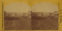
| Date: | 1874 |
|---|---|
| Description: | View looking southwest down the 600 block of Williamson Street to the East Madison Passenger Depot of the Chicago & Northwestern Railroad. There are frame ... |

| Date: | 1867 |
|---|---|
| Description: | Bird's-eye map of Madison with insets of the University, Rasdall House, Vilas House, and the Wisconsin State Capitol. View includes cattail marsh, smokesta... |

| Date: | 1885 |
|---|---|
| Description: | Bird's-eye map of Madison, State Capital of Wisconsin, County Seat of Dane County, with inset of the Wisconsin State Capitol. |

| Date: | 1875 |
|---|---|
| Description: | Bird's-eye map of Mazomanie. |

| Date: | 1911 |
|---|---|
| Description: | Plat Map of Blooming Grove in "Atlas of Dane County, Wisconsin." |

| Date: | 02 08 1970 |
|---|---|
| Description: | Chicago, Milwaukee, St. Paul & Pacific Railroad tracks running down the middle of East Wilson Street from South Baldwin Street to Dickinson Street. |

| Date: | 1904 |
|---|---|
| Description: | This map shows a plat of the east part of the city, numbered blocks and lots, some landownership, local streets, roads, railroads, wards by number, parks, ... |

| Date: | 1904 |
|---|---|
| Description: | This map shows a plat of the west part of the city, numbered blocks and lots, some landownership, local streets, roads, railroads, wards by number, parks, ... |

| Date: | 1855 |
|---|---|
| Description: | Map of the city of Madison, Dane County, published by George Harrison, surveyed and drawn by P. McCabe, and engraved by J.H. Colton & Co., New York. In add... |
| Date: | 01 22 1949 |
|---|---|
| Description: | Aerial view of the town and the Chicago, Milwaukee, St. Paul and Pacific railroad bridge. |

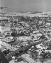
| Date: | 02 09 1949 |
|---|---|
| Description: | Aerial view of Madison, looking east across the Isthmus including the Wisconsin State Capitol, Lake Mendota, and Lake Monona. |

| Date: | 02 25 1949 |
|---|---|
| Description: | One of six aerial images of Mount Horeb. |

| Date: | 1918 |
|---|---|
| Description: | The West Madison Chicago, Milwaukee, and St. Paul railroad station, with train cars on the tracks. |

| Date: | 1873 |
|---|---|
| Description: | Color outline map of Dane County, Wisconsin. |

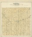
| Date: | 1890 |
|---|---|
| Description: | A plat map of a portion of Verona in Dane County. |
If you didn't find the material you searched for, our Library Reference Staff can help.
Call our reference desk at 608-264-6535 or email us at: