Filter: Categories of Wisconsin Historical Images
Filter: Subject of Revolution, 1775-1783
Filter: Creator Name of Unknown
Filter: Categories of Wisconsin Historical Images
Filter: Subject of Revolution, 1775-1783
Filter: Creator Name of Unknown
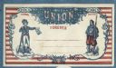
| Date: | 1860 |
|---|---|
| Description: | An intricate design. A blue line frames a background of red horizontal stripes. Inside an ornate border, two figures stand on the left and right. The left ... |
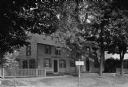
| Date: | |
|---|---|
| Description: | View of a colonial home which became the Daughters of the American Revolution Chapter House in 1894. Tombstones can be seen to the left behind the home. |
| Date: | |
|---|---|
| Description: | Statue of Nathan Hale (1755-1776), a soldier for the Continental Army during the American Revolutionary War. Base of the statue reads, "I only regret that ... |

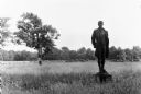
| Date: | |
|---|---|
| Description: | View of the Minuteman Statue in a park setting. The sculpture was completed in 1874 by Daniel Chester French. |
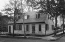
| Date: | |
|---|---|
| Description: | Apothecary Shop of Hugh Mercer (1726-1777), soldier and physician during the Revolutionary War. Erected around 1760, the building was restored to provide m... |
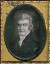
| Date: | 1850 |
|---|---|
| Description: | Ninth plate daguerreotype of a painted quarter-length portrait of Felix Walker, 1793-1828. Mr. Walker fought in the Revolutionary War alongside Daniel Boon... |
| Date: | 1850 |
|---|---|
| Description: | Quarter plate daguerreotype of a painting of Colonel Robert Patterson (1753-1827). Patterson was a pioneer settler to both Kentucky and Ohio. He served in ... |
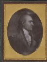
| Date: | 1850 |
|---|---|
| Description: | Sixth plate daguerreotype of a painting of Colonel Robert Weakley. Col. Weakley served as a Representative from Tennessee; born in Halifax County, Va., Jul... |

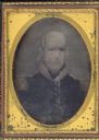
| Date: | |
|---|---|
| Description: | Sixth plate ambrotype of a painting of Captain Samuel Murphy. Murphy served with Captain Samuel Brady in the Pittsburgh region during the Revolutionary War... |
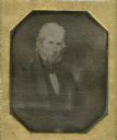
| Date: | 1850 |
|---|---|
| Description: | Quarter plate daguerreotype of a painting of General George Rogers Clark, as an older man. Clark is most well known for his role in the defense of the Nort... |

| Date: | 1776 |
|---|---|
| Description: | This was one of the first maps available for the general British populace featuring America during the Revolutionary War. It includes forts, cities, topogr... |

| Date: | 1776 |
|---|---|
| Description: | Map of the American colonies and land east of the Mississippi River. Prominent cities, forts, Native American land, mountains, rivers and lakes are all sho... |

| Date: | 1782 |
|---|---|
| Description: | Map of America east of the Mississippi River. It shows regions, state boundaries extending to the Mississippi River, cities, forts, Native American lands, ... |
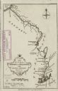
| Date: | 1776 |
|---|---|
| Description: | Map of the Kenebec and Chaudiere River from the Atlantic Ocean to the Saint Lawrence River. Cities, forts, lakes, and tributaries along the two rivers are ... |

| Date: | 1780 |
|---|---|
| Description: | Detailed map of America east of the Louisiana region. It shows forts, cities, borders and boundary lines, Native American land, the post road, mountains, w... |

| Date: | 1775 |
|---|---|
| Description: | Map of Boston and surrounding regions, from Massachusetts Bay to the Connecticut River, and including part of southern New Hampshire. It shows the colonies... |

| Date: | 1776 |
|---|---|
| Description: | Fairly detailed map of New York City and parts of Long Island. It shows streets, roads, wharves, ferries, ship yards, Fort George and the battery, public b... |
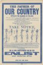
| Date: | 1917 |
|---|---|
| Description: | Poster featuring a reproduction of a Revolutionary War notice calling for soldiers. In addition to its text, this includes illustrations of soldier's posit... |
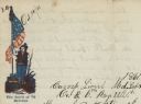
| Date: | 10 10 1861 |
|---|---|
| Description: | Letterhead of a Revolutionary War soldier standing and holding up the American flag in his right hand, and holding a rifle in his left hand. A plow is behi... |
If you didn't find the material you searched for, our Library Reference Staff can help.
Call our reference desk at 608-264-6535 or email us at: