Filter: Categories of Wisconsin Historical Images
Filter: Subject of Rivers
Filter: Year of 1900-1999
Filter: Creator Name of Unknown
Filter: Year of 1970-1979
Filter: Categories of Wisconsin Historical Images
Filter: Subject of Rivers
Filter: Year of 1900-1999
Filter: Creator Name of Unknown
Filter: Year of 1970-1979
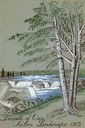
| Date: | 1973 |
|---|---|
| Description: | Cover for the Wisconsin Friends of Our Native Landscape program. Depicted is a river cascading over rocks, and some trees in the foreground. The Wisconsin ... |
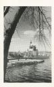
| Date: | 12 12 1973 |
|---|---|
| Description: | Neenah Creek Bridge in Marquette County. |
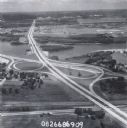
| Date: | 1979 |
|---|---|
| Description: | Interstate I-90 and State Highway 35 at La Crosse. |

| Date: | 09 14 1972 |
|---|---|
| Description: | Elevated view of an inland river barge that was purchased by Electro-Motive and used by Wisconsin Barge Lines. Original Falk caption reads, "4.074:1 twin s... |
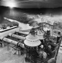
| Date: | 06 06 1977 |
|---|---|
| Description: | Elevated view of a kiln drive that was purchased and used by Dravo Line. Original Falk caption reads, "Color view of May 1977 Pit and Quarry. Photos sent t... |

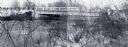
| Date: | 10 1972 |
|---|---|
| Description: | Gaylord Nelson, Patrick Lucey, and Walter Mondale look over the St. Croix River. In the background a bridge is under construction. |
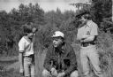
| Date: | 07 1974 |
|---|---|
| Description: | Nelson takes time out during a campaign trip to talk with two boys. Dressed casually, Nelson is shown squatting down in a marsh area between the boys who a... |

| Date: | 1979 |
|---|---|
| Description: | A map of Southern Wisconsin and northern Illinois showing the areas inhabited by the Ho-Chuck, formerly known as the Winnebago. Some of the location names ... |

| Date: | 1975 |
|---|---|
| Description: | This map shows the locations of historic sites and points of interest in Rusk County, Wisconsin. A location key, descriptions of the historical importance ... |

| Date: | 1970 |
|---|---|
| Description: | A map of parks of Kewaunee County, Wisconsin, showing the fishing spots, lakes and parks in the area, it also provides a location map of the area. On the ... |

| Date: | 1976 |
|---|---|
| Description: | An 1876 reprinted map of the Township of Franklin, Milwaukee County, Wisconsin, that shows the land ownership and sectioning of the town, as well as the ro... |

| Date: | 1970 |
|---|---|
| Description: | Color coded map. Legend in the top left hand corner reads: "EXISTING AIRPORT PAVEMENT" (purple), "FUTURE 5-YEAR DEVELOPMENT" (bright pink), "ULTIMATE AIRPO... |

| Date: | 1974 |
|---|---|
| Description: | A map of Dane County from the Charles Brown Atlas. A hand-drawn blue line marks the Black Hawk Trail. |

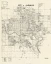
| Date: | 1973 |
|---|---|
| Description: | This map is a photocopy of the original plat of Beloit from 1838. The map shows labeled roads, lots, and rivers. |

| Date: | 1970 |
|---|---|
| Description: | This map shows lot and block numbers, city limits, cemeteries, schools, outdoor theater, Lumberjack Bowl, and Historyland among other attractions. |
| Date: | 1972 |
|---|---|
| Description: | This map shows plat of the city, city limits, local streets, and part of the Baraboo River. The map includes 3 inset maps. |

| Date: | 1974 |
|---|---|
| Description: | This map shows streets, businesses and parks. The Yellow River is labeled. The Plat shows saw mills and land owned by D.R.W. Williams, Wm. Williams, and Jo... |
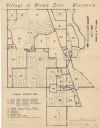
| Date: | 1970 |
|---|---|
| Description: | This blue line map shows zoning districts in the Village of Brown Deer. Includes a key in lower left hand corner. Includes street names. The Milwaukee Rive... |
If you didn't find the material you searched for, our Library Reference Staff can help.
Call our reference desk at 608-264-6535 or email us at: