 Filter: Categories of Wisconsin Historical Images
Filter: Subject of Rivers
Filter: Year of 1900-1999
Filter: Subject of travel
Filter: Categories of Wisconsin Historical Images
Filter: Subject of Rivers
Filter: Year of 1900-1999
Filter: Subject of travel

| Date: | 1941 |
|---|---|
| Description: | Official highway map of Wisconsin, "the playground of the Midwest," showing the state transportation network prior to World War II. |
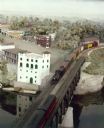
| Date: | 1960 |
|---|---|
| Description: | A Wisconsin Dells minirama miniature model showing a short train with a Prairie-type locomotive on the bridge over the Wisconsin River. |
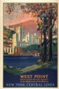
| Date: | 1928 |
|---|---|
| Description: | An original lithograph promoting New York Central Lines railway and the West Point military academy, in a location described as being "In the highlands of ... |
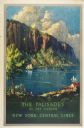
| Date: | 1947 |
|---|---|
| Description: | An original lithograph promoting "The Palisades of the Hudson," via the New York Central lines train system. The poster depicts a dramatic cliff overlookin... |
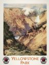
| Date: | 1924 |
|---|---|
| Description: | An original lithograph promoting the Grand Canyon of Yellowstone Park, and to get there by way of the Northern Pacific Railway. The poster depicts a dramat... |
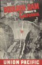
| Date: | 1935 |
|---|---|
| Description: | An original lithograph promoting the Boulder Dam enroute to California via the Union Pacific Railway. The poster features an aerial photograph of the "Worl... |
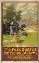
| Date: | 1947 |
|---|---|
| Description: | An original colored lithograph advertising the London Midland and Scottish Railway Company, and promoting Haddon Hall and the Wye Valley as "The Peak Distr... |
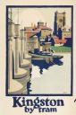
| Date: | 1925 |
|---|---|
| Description: | An original colored lithograph advertising the London Transport system, and promoting travel to "Kingston by Tram." The poster features the artist Frank N... |
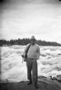
| Date: | 1955 |
|---|---|
| Description: | Sigurd Olson, wearing his characteristic attire, on a trip on the Upper Churchill River. |

| Date: | 1958 |
|---|---|
| Description: | Supreme Court Justice William O. Douglas during a canoe trip with conservationist Sigurd F. Olson. He is sitting with his hat in hand beside a canoe pulled... |
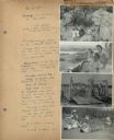
| Date: | 07 22 1941 |
|---|---|
| Description: | Scrapbook page of trip highlights from a bike hosteling trip to Pine Bluff (Dane County), Sauk City (Sauk County), and Okee (Columbia County), sponsored by... |

| Date: | 1910 |
|---|---|
| Description: | Doctor Thorne was one of the members of Carrie's travel party. He is pictured here, in front of Victoria Falls on Livingstone Island. |

| Date: | 1987 |
|---|---|
| Description: | This pictorial map shows roads, bridges, local businesses with phone numbers, and public buildings. Relief is shown pictorially. Also included is a calen... |

| Date: | 1948 |
|---|---|
| Description: | This illustrated map shows major westward trails from 1785 to 1866: Old Oregon Trail and its deviations, Old Spanish Trail, Lewis and Clark route, Santa Fe... |

| Date: | 1935 |
|---|---|
| Description: | This map is presented by Conoco, and shows the major roads, cities, lakes, and rivers, as well as some of the neighboring states. It includes an index, sca... |

| Date: | 1946 |
|---|---|
| Description: | This colored road map shows automobile roads in Wisconsin as well as portions of nearby states. Information on the quality and type of any road shown (Inte... |

| Date: | 1948 |
|---|---|
| Description: | This colored road map shows automobile roads in Wisconsin as well as portions of nearby states.Information on the quality and type of any road shown (bitum... |

| Date: | 1948 |
|---|---|
| Description: | This colored road map shows automobile roads in Wisconsin as well as portions of nearby states. The map is organized such that a single map of Wisconsin is... |

| Date: | 1956 |
|---|---|
| Description: | This colored road map shows automobile roads in Wisconsin as well as portions of nearby states. The map is organized such that a single map of Wisconsin is... |

| Date: | 1959 |
|---|---|
| Description: | This colored road map shows roads in Wisconsin as well as portions of nearby states. Information on the quality and type of any road shown (expressways, St... |
If you didn't find the material you searched for, our Library Reference Staff can help.
Call our reference desk at 608-264-6535 or email us at: