 Filter: Categories of Wisconsin Historical Images
Filter: Subject of Rivers
Filter: Year of 1900-1999
Filter: Year of 1930-1939
Filter: County of Douglas
Filter: Categories of Wisconsin Historical Images
Filter: Subject of Rivers
Filter: Year of 1900-1999
Filter: Year of 1930-1939
Filter: County of Douglas

| Date: | 1930 |
|---|---|
| Description: | View of bridge and Brule River monument. Placed where the Brule River is crossed by the Memorial Highway from Superior to Brule and Ashland (Highway 2). |
| Date: | 1930 |
|---|---|
| Description: | Cedar Island on Brule River, a nationally known speckle trout stream. The island has native towering white pine and bubbling clear springs. These are some ... |
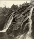
| Date: | 1938 |
|---|---|
| Description: | Little Manitou Falls on the Black River. Referred to as the "upper falls" in the park. A person is sitting on the rocks on top of the falls. This waterfall... |
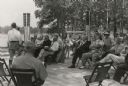
| Date: | 07 06 1937 |
|---|---|
| Description: | Dedication ceremony for the dam on the St. Croix River that is now part of the Gordon Dam County Park. Construction on this dam was begun as a WPA project... |
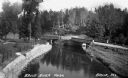
| Date: | 1935 |
|---|---|
| Description: | Elevated view of the Brule River in northern Wisconsin, flowing between a road and landscaped stone wall under a bridge and pedestrian walkway. |
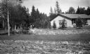
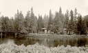
| Date: | 1935 |
|---|---|
| Description: | A one-story building is situated amongst young evergreens and surrounded by stone walls containing river raceways for spawning fish. A group of people are ... |

| Date: | 1930 |
|---|---|
| Description: | Shows county system of roads which are surfaced, well graded, common, or unimproved, town roads, state trunk highways, town and village boundaries, schools... |

| Date: | 1930 |
|---|---|
| Description: | Shows county system of roads which are surfaced, well graded, common, or unimproved, town roads, state trunk highways, town and village boundaries, schools... |

| Date: | 1934 |
|---|---|
| Description: | This map shows industrial points of interest in Superior. The top of the map reads: "Superior, Douglas County, Wisconsin, as this Industrial Tour map indic... |

| Date: | 1932 |
|---|---|
| Description: | This map of Superior shows many points of interests including camping, fair grounds, docks, tourist attractions, lakes, roads, and waterways. |

| Date: | 1935 |
|---|---|
| Description: | This map shows rivers, lakes, communities, woods, fishing locations, and vacation destinations. The back of the map includes text about agricultural, sceni... |

| Date: | 1935 |
|---|---|
| Description: | A man kneeling on a wharf holds the bow of a canoe while two others stand nearby. The man at far right carries a long fishing rod. There is a trailer on ... |

| Date: | 1935 |
|---|---|
| Description: | A flash photograph of a large whitetail buck standing in shallow water of the Brule River. |

| Date: | 1935 |
|---|---|
| Description: | The description on the negative envelope reads: "David Sample, guide at Brule, Wisconsin, taking a tourist down the fast moving waters of the Brule River."... |
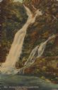
| Date: | 1938 |
|---|---|
| Description: | Text on front reads: "Manitou Falls, Pattison State Park, Superior, Wis." On reverse: "Manitou Falls, with a specacular drop of 165 ft., is the most outsta... |
If you didn't find the material you searched for, our Library Reference Staff can help.
Call our reference desk at 608-264-6535 or email us at: