 Filter: Categories of Wisconsin Historical Images
Filter: Subject of Rivers
Filter: Year of 1900-1999
Filter: Year of 1940-1949
Filter: Categories of Wisconsin Historical Images
Filter: Subject of Rivers
Filter: Year of 1900-1999
Filter: Year of 1940-1949

| Date: | 1940 |
|---|---|
| Description: | This map shows a canoe route between Madison and Milwaukee. Includes text and an inset map of the route from Milwaukee to Madison. Shows the area around We... |

| Date: | 1940 |
|---|---|
| Description: | This map shows lakes, roads, car trails, foot trails, railroads, resorts and camps, and fire towers. The map includes an inset location map and pictorial d... |

| Date: | 1941 |
|---|---|
| Description: | This map highlights the fishing district and shows labeled rivers, lakes, cities, county boundaries and points of interest. The map includes a list of trai... |

| Date: | 1942 |
|---|---|
| Description: | This map shows a paper city laid out in 1836 on the Wisconsin River, now the site of Wyalusing State Park, Grant County. The upper right corner includes a ... |

| Date: | 1942 |
|---|---|
| Description: | This photostat map shows roads, ferry, impassible marsh land, the Menominee River, the Milwaukee River, and Lake Michigan. |

| Date: | 1941 |
|---|---|
| Description: | August Derleth posing on a boat tied up to a pier on the Wisconsin River. With him are Ruth Marshall (seated), another woman, and a dog. Four men are stand... |

| Date: | 1946 |
|---|---|
| Description: | This colored road map shows automobile roads in Wisconsin as well as portions of nearby states. Information on the quality and type of any road shown (Inte... |

| Date: | 1948 |
|---|---|
| Description: | This colored road map shows automobile roads in Wisconsin as well as portions of nearby states.Information on the quality and type of any road shown (bitum... |

| Date: | 1948 |
|---|---|
| Description: | This colored road map shows automobile roads in Wisconsin as well as portions of nearby states. The map is organized such that a single map of Wisconsin is... |

| Date: | 1941 |
|---|---|
| Description: | Elevated view of a highway bridge spanning the Fox River. Caption reads: "Claude Allouez Bridge at De Pere, Near Green Bay, Wis." |

| Date: | 1947 |
|---|---|
| Description: | Elevated view of the bridge and main building on the opposite shoreline at Pamperin Park. Caption reads: "Pamperin Park, Green Bay, Wis." |
| Date: | 1948 |
|---|---|
| Description: | View of the flowage of the Totogatic, a designated wild river. Three rowboats are anchored just off shore. |
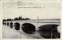
| Date: | 1945 |
|---|---|
| Description: | View across water toward a concrete arch bridge over the Rock River. Caption reads: "Jackson Street Bridge, Janesville, Wis." |
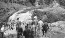
| Date: | 08 1940 |
|---|---|
| Description: | Elevated view of a group of Georgia Junior Rangers and their guides viewing the Copper Falls of the Bad River. |
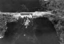
| Date: | 1940 |
|---|---|
| Description: | Aerial view, looking upstream, of water flowing through a dam. On the reverse of the print is written: "Dam built by WPA on site of old logging dam on the ... |

| Date: | 1942 |
|---|---|
| Description: | Black and white aerial view of La Crosse and the Mississippi River, including Riverside Park, the Black River and La Crosse River. |
| Date: | 1940 |
|---|---|
| Description: | Boys are roasting weiners at a stone fire ring overlooking the Chippewa River in Brunet Island State Park. A man on the far right, behind trees, is walking... |

| Date: | 1940 |
|---|---|
| Description: | Photographic postcard view from shoreline looking downstream at the Fox River locks, with a bridge behind it. A boat is tied along the shoreline just below... |

| Date: | 1940 |
|---|---|
| Description: | Photographic postcard view from shoreline looking down towards a woman wearing a hat who is sitting and fishing from one of four rowboats tied up at the sh... |

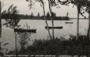
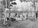
| Date: | 1940 |
|---|---|
| Description: | A man, sitting on a wooden bench, and a woman, sitting on the ground, are enjoying a picnic on the shore of the Flambeau River. There is an open plaid meta... |
If you didn't find the material you searched for, our Library Reference Staff can help.
Call our reference desk at 608-264-6535 or email us at: