Filter: Categories of Wisconsin Historical Images
Filter: Subject of Rivers
Filter: Year of 1900-1999
Filter: Year of 1970-1979
Filter: Categories of Wisconsin Historical Images
Filter: Subject of Rivers
Filter: Year of 1900-1999
Filter: Year of 1970-1979

| Date: | 1978 |
|---|---|
| Description: | Three-quarter view from front of driver's side of red Scout II with roof rack and white detailing, with the name "rallye" on front panel in front of driver... |

| Date: | 1978 |
|---|---|
| Description: | View from shoreline of Scout II being driven across a river. Trees, hills and a mountain are in the background. The red Scout II has a roof rack and white... |

| Date: | 1978 |
|---|---|
| Description: | View from shoreline of Scout II being driven across a river. Trees, hills and a mountain are in the background. The red Scout II has a roof rack and white ... |

| Date: | 1978 |
|---|---|
| Description: | View from shoreline of Scout II being driven across a river. Trees, hills and a mountain are in the background. The red Scout II has a roof rack and white ... |

| Date: | 04 1973 |
|---|---|
| Description: | View across water through trees towards a house above the banks of the flooded Baraboo river. |

| Date: | 1974 |
|---|---|
| Description: | This map shows streets, Lake Winnebago, Little Lake Butte Des Morts, and the Fox River. Also included is text on the Fox River Waterways and the history of... |

| Date: | 1974 |
|---|---|
| Description: | Map of Wisconsin with drawings illustrating historic places and events throughout the state. The Great Seal of the State of Wisconsin appears at the top ri... |

| Date: | 1975 |
|---|---|
| Description: | This map provides an index of quadrangle maps for the state. The lower left corner contains explanation land surveying completeness. Communities, counties,... |

| Date: | 1975 |
|---|---|
| Description: | This map provides an index of outdated quadrangle maps for the state. Communities, counties, rivers, and lakes are labeled including Lake Michigan and Lake... |
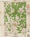
| Date: | 1975 |
|---|---|
| Description: | This map shows points of interest in south central Wisconsin from the Wisconsin Dells and the Baraboo Hills down to Madison and Blue Mounds. Interest point... |

| Date: | 1974 |
|---|---|
| Description: | This map shows streets, businesses and parks. The Yellow River is labeled. The Plat shows saw mills and land owned by D.R.W. Williams, Wm. Williams, and Jo... |
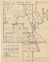
| Date: | 1970 |
|---|---|
| Description: | This blue line map shows zoning districts in the Village of Brown Deer. Includes a key in lower left hand corner. Includes street names. The Milwaukee Rive... |

| Date: | 1970 |
|---|---|
| Description: | This map shows land owned by Menominee Enterprise Inc., land sold to Menominee shareholders, and land sold to non-Menominees. The map also includes water a... |

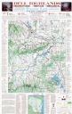
| Date: | 1975 |
|---|---|
| Description: | This map shows nature trails, public attractions, public hunting and fishing grounds, dams, waysides, lakes, highways, and roads. The upper right corner in... |
| Date: | 05 06 1973 |
|---|---|
| Description: | Black ink line drawing of a fisherman on the bank of Big Spring Creek near a power house and dam. Puffy clouds fill the sky in the background and thick veg... |
| Date: | 1971 |
|---|---|
| Description: | This map shows major tributaries, and also covers parts of Marathon and Portage Counties. |

| Date: | 1972 |
|---|---|
| Description: | Imaginative pen-and-ink drawing of a view from across a stream towards a cigar-smoking fisherman (probably Sid Boyum) on the opposite side of the bank. He ... |
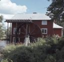
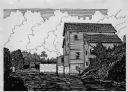
| Date: | 08 1972 |
|---|---|
| Description: | View along shoreline towards a red mill building with a wood waterwheel on a river. |
If you didn't find the material you searched for, our Library Reference Staff can help.
Call our reference desk at 608-264-6535 or email us at: