Filter: Categories of Wisconsin Historical Images
Filter: Subject of Valleys
Filter: Subject of land
Filter: Categories of Wisconsin Historical Images
Filter: Subject of Valleys
Filter: Subject of land

| Date: | 1921 |
|---|---|
| Description: | Group portrait of four people standing in front of a wire fence on the edge of a cliff, with trees and a valley in the background. Walter Alexander stands ... |

| Date: | 10 1891 |
|---|---|
| Description: | This blueprint map shows land ownership and buildings. Text below the title reads: "The La Crosse Heights include the ridge of land with the spurs projecti... |

| Date: | |
|---|---|
| Description: | View looking down hill towards a tree-filled valley near Maiden Rock. |

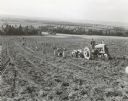
| Date: | 1900 |
|---|---|
| Description: | Elevated view across field towards men harvesting in a field near large haystacks. In the background is a mountain village at the lower level of a mountain... |

| Date: | 1900 |
|---|---|
| Description: | Slightly elevated view of a large group of people posing in a field. Men, women and children are posing near five horse-drawn McCormick binders. A group of... |

| Date: | 1940 |
|---|---|
| Description: | View from rear of Elmer Tompkin driving a Farmall M tractor down a hilly field. The tractor is pulling a No. 12 two-row digger on Elmer Merrill's 400-acre ... |
| Date: | 1940 |
|---|---|
| Description: | Three-quarter view from front right of Elmer Tompkin driving a Farmall M tractor down a hilly field. The tractor is pulling a No. 12 two-row digger on Elme... |

| Date: | 1941 |
|---|---|
| Description: | View down hill towards a group of men with a TD-14 and 51 combine owned by Eaton Sisters. They are harvesting mustard. Below them in the valley are farm bu... |

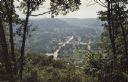
| Date: | 1922 |
|---|---|
| Description: | Elevated view of Chaseburg and the surrounding landscape, with a river and bluffs in the background. Caption reads: "Chaseburg, Wis." |

| Date: | |
|---|---|
| Description: | Elevated view of a valley between tree-covered hills. There is a lake or river, and a far shoreline in the distance. |

| Date: | |
|---|---|
| Description: | View from a dirt road towards a field in a valley of low bluffs. Farm buildings are near a base of the bluffs at the far edge of the field. |

| Date: | 10 18 1978 |
|---|---|
| Description: | View down Old Sauk Pass towards a house in a valley during a rainstorm in rural Wisconsin. |

| Date: | 1839 |
|---|---|
| Description: | This map shows the geological makeup of the valley in red, yellow, and green, the Mississippi River, and the location of Fort Crawford. The geology on the ... |
| Date: | 1866 |
|---|---|
| Description: | An accompaniment to a Gilpin County, Colorado map created by Morse and George Hill. |

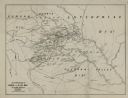
| Date: | 1760 |
|---|---|
| Description: | Map showing the towns, mountains, valleys, corn fields, and rivers of a portion of the Cherokee Nation. A few annotations on the map explain the land and r... |

| Date: | |
|---|---|
| Description: | Photo collage of Sid sitting on the edge of a rocky overlook. Fields and hills are in the valley below. |

| Date: | 1972 |
|---|---|
| Description: | Three-quarter view from front left of a man operating a TD-25 on the side of a hill. There is a valley in the background. Vecellio and Grogan, Inc., workin... |

| Date: | 1972 |
|---|---|
| Description: | Elevated view of men operating Pay Haulers and a Pay Loader at the top of a hill. Vecellio and Grogan, Inc., working on highway project cutting four and on... |

| Date: | 1914 |
|---|---|
| Description: | Elevated view across valley towards a pass in the Sawtooth Mountains, with a very tall, bare tree in the foreground. |
If you didn't find the material you searched for, our Library Reference Staff can help.
Call our reference desk at 608-264-6535 or email us at: