 Filter: Categories of Wisconsin Historical Images
Filter: Subject of War
Filter: Categories of Wisconsin Historical Images
Filter: Subject of War

| Date: | |
|---|---|
| Description: | Drawing of a soldier, wearing a backpack and a helmet that covers his eyes, sitting next to a missile, labeled "HATE." In the sky is the word: "POLITICS." ... |

| Date: | 1758 |
|---|---|
| Description: | Map showing lakes, rivers, cities, Native American land, and the boundaries of French and English claims in America and Canada north of New York. A title c... |

| Date: | 1755 |
|---|---|
| Description: | Map of colonial America, showing the lands north of South Carolina and west of the Mississippi River. An inset map of the Carolinas and Georgia sits in the... |

| Date: | 1777 |
|---|---|
| Description: | Map of Colonial America east of Lake Michigan showing regions, cities, forts, Native American land, mountains, lakes, and rivers. Crossed swords and small ... |

| Date: | 1795 |
|---|---|
| Description: | Map of the United States east of the Mississippi River. It features roads, cities, towns, early settlements, Native American land, forts, mountains, rivers... |

| Date: | 1755 |
|---|---|
| Description: | Map of New England, with three inset maps of Fort Oswego, Fort du Quesne, and Fort Frederick. It shows colonies, a few cities, forts (marked as French or E... |

| Date: | 1760 |
|---|---|
| Description: | Map showing upstate New York, Lake Ontario, and the St. Lawrence River during the last, decisive battle of the French and Indian War. The main map shows a ... |

| Date: | 1780 |
|---|---|
| Description: | Detailed topographical and political map of the area from Lake Champlain to Albany and the Hudson River. Relief is shown through hachures. The map shows ci... |

| Date: | 10 1776 |
|---|---|
| Description: | Broadside map showing the British invasion of New York city in August and September of 1776. The map shows important cities, forts, roads, hills, mountains... |

| Date: | 1781 |
|---|---|
| Description: | Map of the southern portion of the Chesapeake Bay and surrounding lands. It shows counties, a few cities and towns, forts, roads, islands, topographical fe... |
| Date: | |
|---|---|
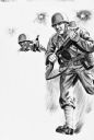
| Description: | Partial illustration art of two American World War II soldiers in military uniform and helmets holding rifles as they advance under exploding artillery ove... |

| Date: | |
|---|---|
| Description: | A large group of men are pulling the wooden Trojan horse through a large gate, and into the city of Troy, as people cheer in a scene from the film Helen of... |
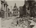
| Date: | 1918 |
|---|---|
| Description: | Street in Fismes, France destroyed during the Battle of Fismes. The badly damaged town hall can be seen near the center, with rubble from other buildings i... |

| Date: | |
|---|---|
| Description: | Bumper sticker with message opposing the military government of El Salvador. It reads: "Not a dime for death squad government in El Salvador." |

| Date: | |
|---|---|
| Description: | Poster opposing military aid to the government of El Salvador featuring an illustration of silhouetted helicopters spraying red gas towards two people in s... |

| Date: | |
|---|---|
| Description: | Poster opposing aid to the military government of El Salvador. It features an image of a blood red dollar sign, and a bound and blindfolded body lying in a... |
| Date: | 1918 |
|---|---|
| Description: | Poster featuring an illustration of a woman wearing clothing with the Red Cross insignia on it. She is standing in the middle of a crowd of children. Anoth... |
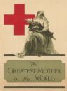
| Date: | 1918 |
|---|---|
| Description: | Poster featuring an illustration of a monumental woman cradling a wounded man. She is wearing a Red Cross hat, and the Red Cross insignia behind her on the... |
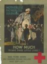
| Date: | 1918 |
|---|---|
| Description: | Poster featuring an illustration of a man in a uniform walking on the left side. Behind him is the Red Cross insignia is in the top left side of the poster... |

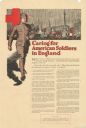
| Date: | 1918 |
|---|---|
| Description: | Poster featuring an illustration of a woman and two children standing together. The woman is wearing a Red Cross hat. There Red Cross insignia is in the up... |
If you didn't find the material you searched for, our Library Reference Staff can help.
Call our reference desk at 608-264-6535 or email us at: