Filter: Categories of Wisconsin Historical Images
Filter: Subject of Waterfalls
Filter: Subject of botany
Filter: Categories of Wisconsin Historical Images
Filter: Subject of Waterfalls
Filter: Subject of botany

| Date: | |
|---|---|
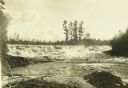
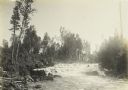
| Description: | View up center of river with rushing waters, surrounded by rock cliffs. |

| Date: | |
|---|---|
| Description: | Elevated view looking down at a steep waterfall surrounded by cliffs. The tops of the cliffs and surrounding area are covered by trees and shrubs. A large ... |

| Date: | |
|---|---|
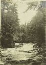
| Description: | View from rocky shoreline across a pool in a river with a small waterfall in the background. Trees and shrubs line the opposite shoreline. |

| Date: | |
|---|---|
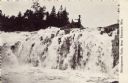
| Description: | Elevated view looking across towards Big Manitou Falls, a waterfall in Pattison State Park. The falls are surrounded by trees and rocks. Pattison State Par... |

| Date: | |
|---|---|
| Description: | View looking up to two waterfalls, which flow side by side. |

| Date: | |
|---|---|
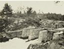
| Description: | View across water looking up towards waterfall in a river, surrounded by trees. There are wood posts, perhaps part of a dam, along the top of the waterfall... |
| Date: | |
|---|---|
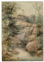
| Description: | Watercolor painting of a cascade of water over boulders in a stream. Trees and foliage are growing on both sides. The scene may be Madison Creek, west of... |
| Date: | |
|---|---|
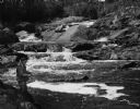
| Description: | View along shoreline towards a man fishing on a river with a series of small waterfalls behind him. |

| Date: | |
|---|---|
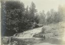
| Description: | Elevated view over pool framed by trees towards water flowing down a series of small waterfalls over low rock formations into the pool of water. |

| Date: | 1758 |
|---|---|
| Description: | This map of the north-west hemisphere shows the cities, lakes, rivers, mountains, and political borders. In the upper left corner sits a decorative cartouc... |

| Date: | 1783 |
|---|---|
| Description: | This map is hand-colored and shows the boundaries of British, Spanish, and the newly recognized American claims, as well as the fishing rights granted to F... |

| Date: | 1795 |
|---|---|
| Description: | Map of Vermont showing counties, townships, cities, roads, mountains, lakes, and rivers. A forest and waterfall scene decorates the title cartouche in the ... |

| Date: | 1756 |
|---|---|
| Description: | Map of Pennsylvania, showing cities, towns, roads, trading paths, portages, forts, mountains, swamps, waterfalls, lakes, and rivers. The map further includ... |

| Date: | 1760 |
|---|---|
| Description: | Map showing the towns, mountains, valleys, corn fields, and rivers of a portion of the Cherokee Nation. A few annotations on the map explain the land and r... |
| Date: | |
|---|---|
| Description: | View of a waterfall with a man fishing from the top. Caption reads: "Michigamme Falls, Near Florence, Wis." |
| Date: | 1914 |
|---|---|
| Description: | The Flute Reed River at Chicago Bay. Chicago Bay, Minnesota, is now called Hovland. |
| Date: | 08 1915 |
|---|---|
| Description: | A view of water rushing over rocks in the Vermillion River. |
| Date: | 1909 |
|---|---|
| Description: | Cascades on the Presque Isle River near The Gang's camp. |
If you didn't find the material you searched for, our Library Reference Staff can help.
Call our reference desk at 608-264-6535 or email us at: