 Filter: Categories of Wisconsin Historical Images
Filter: Subject of battles
Filter: Categories of Wisconsin Historical Images
Filter: Subject of battles

| Date: | 1916 |
|---|---|
| Description: | Still of actors portraying soldiers in a battle. Caption reads: "King Lear performance (for motion picture?)" |

| Date: | 1900 |
|---|---|
| Description: | A hand-drawn map of the battlefield of the Battle of Chickamauga. |

| Date: | 1863 |
|---|---|
| Description: | A Gettysburg battle casualty tabulation in Rufus Dawes' diary noting how many people were killed, wounded, and missing. |
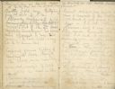
| Date: | 07 01 1863 |
|---|---|
| Description: | A two page diary entry written at the Gettysburg battlefield by Rufus R. Dawes. |

| Date: | 1615 |
|---|---|
| Description: | Illustration of the Huron Indians and French explorers attacking an Iroquois fort near present day Fenner, New York. A wooden platform was constructed to f... |

| Date: | 1609 |
|---|---|
| Description: | Illustration of an elevated view of a battle between Iroquois tribe and French on the banks of river. The Iroquois are unclothed and armed with bows and ar... |

| Date: | 1918 |
|---|---|
| Description: | Poster with an illustration of a young drummer boy leading troops carrying ragged flags into battle. There is a large transparent figure of Marianne in the... |
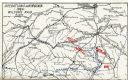
| Date: | 1909 |
|---|---|
| Description: | Map showing operations in Virginia during Wilson's Raid. |

| Date: | 07 14 1863 |
|---|---|
| Description: | An account of the Battle of Gettysburg written in pencil in the diary of Rufus Dawes. |

| Date: | 1775 |
|---|---|
| Description: | Map of Boston and surrounding regions, from Massachusetts Bay to the Connecticut River, and including part of southern New Hampshire. It shows the colonies... |

| Date: | 1755 |
|---|---|
| Description: | Map of New England, with three inset maps of Fort Oswego, Fort du Quesne, and Fort Frederick. It shows colonies, a few cities, forts (marked as French or E... |

| Date: | 1795 |
|---|---|
| Description: | Map of the United States east of the Mississippi River. It features roads, cities, towns, early settlements, Native American land, forts, mountains, rivers... |

| Date: | 1777 |
|---|---|
| Description: | Map of Colonial America east of Lake Michigan showing regions, cities, forts, Native American land, mountains, lakes, and rivers. Crossed swords and small ... |

| Date: | 1767 |
|---|---|
| Description: | Map of the north east coast of America, showing colonial borders, cities, Native American land, lakes, rivers, and a few hills and mountains. Illustrated t... |

| Date: | 1733 |
|---|---|
| Description: | This map of North America shows settlements, rivers, lakes, Native American land, trade winds, and numerous topographical features such as forests and moun... |

| Date: | 1777 |
|---|---|
| Description: | Map showing the Hudson River in three sections, from New York City up through Lake Champlain, including cities, forts, roads, topographical features, and n... |

| Date: | 1770 |
|---|---|
| Description: | Map of North America from the Great Lakes to the northern portion of South America. It shows cities, Native American land, mountains, swamps, lakes, rivers... |

| Date: | 1961 |
|---|---|
| Description: | View from behind of a Chinese National Marine firing a gun at night in Laos. |

| Date: | 05 01 1899 |
|---|---|
| Description: | Map showing the Schuylkill River with roads, ferries, and points of interest from Valley Forge to Philadelphia, Pennsylvania as it appeared during the Revo... |
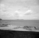
| Date: | 08 31 1944 |
|---|---|
| Description: | View from shoreline of Cezembre Island, just north of Saint-Malo on the north coast of France. It was German-occupied until the Allies mounted an operation... |
If you didn't find the material you searched for, our Library Reference Staff can help.
Call our reference desk at 608-264-6535 or email us at: