 Filter: Categories of Wisconsin Historical Images
Filter: Subject of great lakes
Filter: Categories of Wisconsin Historical Images
Filter: Subject of great lakes

| Date: | 1757 |
|---|---|
| Description: | The Canadian Lakes. Scale [ca. 1:6,500,000]. Paris: 1757. |

| Date: | 09 1918 |
|---|---|
| Description: | An insurance map of Washburn, with an index and a key. Includes a small inset map of the State of Wisconsin that shows "Location of this town as above unde... |

| Date: | 1997 |
|---|---|
| Description: | System map including Wisconsin Central LTD., Fox Valley and Western LTD., Algoma Central Railway, Inc., and Sault Ste. Marie Bridge Co. Detail maps at top ... |

| Date: | 1978 |
|---|---|
| Description: | Text on reverse reads: "The Seamen's Memorial Statue, Barker's Island, Superior, WI. Facing the harbor holding a massive cable is the 10 foot tall Seamen's... |
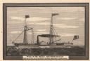
| Date: | 03 1882 |
|---|---|
| Description: | Engraving after a drawing of the steamer Walk-in-the-Water, the first steamboat to sail the Great Lakes. |

| Date: | 1935 |
|---|---|
| Description: | Polygonic projection map of the lower part of Lake Michigan, surrounded by the states of Wisconsin, Illinois, Indiana, Michigan. Includes handwritten text ... |

| Date: | 01 10 1923 |
|---|---|
| Description: | Drawing of an aerial view of factory in Chatham, Ontario. |

| Date: | 01 10 1923 |
|---|---|
| Description: | Drawing of aerial view of Harvester Works in Hamilton, Ontario, in Canada. |

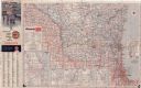
| Date: | 1966 |
|---|---|
| Description: | This colored road map shows automobile roads in Wisconsin as well as portions of nearby states. Information on the quality and type of any road shown (inte... |

| Date: | 1965 |
|---|---|
| Description: | This colored road map shows automobile roads in Wisconsin as well as portions of nearby states. Information on the quality and type of any road shown (inte... |

| Date: | 1957 |
|---|---|
| Description: | This colored road map shows automobile roads in Wisconsin as well as portions of nearby states. The map is organized such that a single map of Wisconsin is... |

| Date: | 1959 |
|---|---|
| Description: | This colored road map shows roads in Wisconsin as well as portions of nearby states. Information on the quality and type of any road shown (expressways, St... |

| Date: | 1960 |
|---|---|
| Description: | This colored road map shows roads in Wisconsin as well as portions of nearby states. Information on the quality and type of any road shown can be found in ... |

| Date: | 1962 |
|---|---|
| Description: | This colored road map shows roads in Wisconsin as well as portions of nearby states. The map is organized such that a single map of Wisconsin is divided on... |
| Date: | 1962 |
|---|---|
| Description: | This colored road map shows roads in Wisconsin as well as portions of nearby states. The map is organized such that a single map of Wisconsin is divided on... |

| Date: | 1963 |
|---|---|
| Description: | This colored road map shows automobile roads in Wisconsin as well as portions of nearby states. The map is organized such that a single map of Wisconsin is... |

| Date: | 1948 |
|---|---|
| Description: | This colored road map shows automobile roads in Wisconsin as well as portions of nearby states. The map is organized such that a single map of Wisconsin is... |

| Date: | 1948 |
|---|---|
| Description: | This colored road map shows automobile roads in Wisconsin as well as portions of nearby states. The map is organized such that a single map of Wisconsin is... |

| Date: | 1946 |
|---|---|
| Description: | This colored road map shows automobile roads in Wisconsin as well as portions of nearby states. Information on the quality and type of any road shown (Inte... |

| Date: | 1938 |
|---|---|
| Description: | This colored road map shows automobile roads in Wisconsin as well as portions of nearby states. Along the bottom edge of the front page, smaller road maps ... |
If you didn't find the material you searched for, our Library Reference Staff can help.
Call our reference desk at 608-264-6535 or email us at: