 Filter: Categories of Wisconsin Historical Images
Filter: State of Virginia
Filter: Subject of battles
Filter: Categories of Wisconsin Historical Images
Filter: State of Virginia
Filter: Subject of battles

| Date: | 07 04 1776 |
|---|---|
| Description: | Hand-drawn map of the area where the Battle of Black's Fort took place. |
| Date: | |
|---|---|
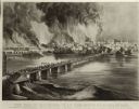
| Description: | Currier & Ives lithograph of the fall of Richmond, April 2, 1865. |
| Date: | |
|---|---|
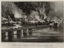
| Description: | "The Evacuation of Richmond Virginia. By the Government of the Southern Confederacy on the Night of April 2nd 1865." Before evacuating, the Confederates se... |

| Date: | |
|---|---|
| Description: | A painting of 'The Charge of the New Market Cadets' by West Clinedinst (Clinedienst). The work commemorates the Battle of New Market that took place on May... |
| Date: | |
|---|---|
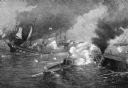
| Description: | A painting of 'The Battle Between the Monitor and the Merrimac.' The work commemorates the Battle of Hampton Roads, fought on March 8–9, 1862, and depicts ... |

| Date: | 1861 |
|---|---|
| Description: | This map shows Manassas during the First Battle of Bull Run, in which the 2nd Wisconsin Infantry fought, and the Leesburg area, the site of the Battle of B... |

| Date: | 1862 |
|---|---|
| Description: | This map illustrates the official plan for the siege of Yorktown, Virginia, and indicates the headquarters of Generals McClellan, Porter, Woodbury, and Hei... |

| Date: | 1862 |
|---|---|
| Description: | This map shows the region of southeastern Virginia which served as the setting for the Peninsular Campaign of 1862. A few battle sites are marked by crosse... |

| Date: | 1862 |
|---|---|
| Description: | This pen and ink drawing of the First Battle of Bull Run, JuIy 21st, 1861, was made by Charles K. Dean, adjutant with the 2nd Wisconsin Infantry. The 2nd W... |

| Date: | 1864 |
|---|---|
| Description: | This map of the battlefield on the North Anna River at Hanover Junction illustrates the Union positions in blue and Confederate positions in red. Roads, ra... |

| Date: | 1864 |
|---|---|
| Description: | This colored map shows cities, rail lines, and geographic features in eastern Virginia. Circles around Richmond at 10 mile intervals indicate distances fro... |

| Date: | 1864 |
|---|---|
| Description: | This map of the battlefield at Wilderness, Virginia, illustrates the Union positions in blue and Confederate positions in red. Roads, railroads, vegetation... |

| Date: | 1864 |
|---|---|
| Description: | This battlefield map of the Battle of Totopotomoy Creek, also known as the Battle of Bethesda Church, shows the railroads, roads, vegetation and topography... |

| Date: | 1864 |
|---|---|
| Description: | This battlefield map of the Battle of Totopotomoy Creek, also known as the Battle of Bethesda Church, shows the railroads, roads, vegetation and topography... |

| Date: | 1864 |
|---|---|
| Description: | This map of the area of the First Battle of Bull Run shows military positions and troop movements as well as the names of landowners, vegetation and land u... |

| Date: | 1865 |
|---|---|
| Description: | This map of the battlefield at Spotsylvania Courthouse illustrates the Union positions in blue and Confederate positions in red. Roads, railroads, vegetati... |

| Date: | 1865 |
|---|---|
| Description: | This map of the battlefield at Five Forks, Va., shows Union and Confederate positions, roads, drainage, vegetation, relief by hachures, and names of reside... |

| Date: | 1865 |
|---|---|
| Description: | Map extends from Harper's Ferry in the north to Petersburg in the south and from Lexington east to Heathsville. The routes of the II, V, VI, IX, XVIII, and... |

| Date: | 1865 |
|---|---|
| Description: | This detailed map of the area between Richmond and Petersburg shows fortifications, roads, railroads, towns, street patterns of Petersburg and Richmond, dr... |
| Date: | 1865 |
|---|---|
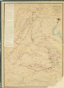
| Description: | This map shows the seven raids made in central Virginia by cavalry under the command of Maj. Gen. Philip H. Sheridan between May 9, 1864, and May 3, 1865. |
If you didn't find the material you searched for, our Library Reference Staff can help.
Call our reference desk at 608-264-6535 or email us at: