 Filter: Categories of Wisconsin Historical Images
Filter: State of Virginia
Filter: Subject of civil war, 1861-1865
Filter: Categories of Wisconsin Historical Images
Filter: State of Virginia
Filter: Subject of civil war, 1861-1865

| Date: | 1880 |
|---|---|
| Description: | Interior view of Washington and Lee University chapel showing tomb of Robert E. Lee. Portraits hang on the wall around an arch leading to the tomb. |

| Date: | 1907 |
|---|---|
| Description: | Colored postcard view of crowd in front of the stand. Caption reads: "Human Confederate Flag." Text at top right reads: "And 'twill live in song and story.... |

| Date: | |
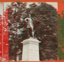
|---|---|
| Description: | A monument and statue honoring the Confederate general Thomas Jonathan "Stonewall" Jackson. There is a cemetery in the background on the left. |
| Date: | 1864 |
|---|---|
| Description: | An albumen stereograph of a monument to the Confederate dead, in the shape of a stone pyramid with steeply pitched sides. |
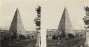
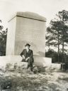
| Date: | 1870 |
|---|---|
| Description: | A stereograph of a statue of Thomas J. "Stonewall" Jackson. |
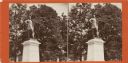
| Date: | 1915 |
|---|---|
| Description: | A monument dedicated to the 36th Wisconsin Volunteer Infantry, Companies B, E, F, and G. These companies were part of the Army of the Potomac, who fought a... |
| Date: | 1870 |
|---|---|
| Description: | A stereograph of a statue of Thomas J. "Stonewall" Jackson. |

| Date: | 1864 |
|---|---|
| Description: | Stereograph of the main building, a tenement (loft style) building, at Libby Prison. |

| Date: | |
|---|---|
| Description: | Portrait of General Robert E. Lee (1807-1870). The original photograph taken in 1865 is located at Washington and Lee University. |

| Date: | |
|---|---|
| Description: | Effigy tomb of General Robert E. Lee (1807-1870), at Washington and Lee University. |

| Date: | |
|---|---|
| Description: | Monument tomb of General Sheridan (1831-1888), Union general in the Civil War. |

| Date: | 1861 |
|---|---|
| Description: | This map shows Manassas during the First Battle of Bull Run, in which the 2nd Wisconsin Infantry fought, and the Leesburg area, the site of the Battle of B... |

| Date: | 1862 |
|---|---|
| Description: | This map illustrates the official plan for the siege of Yorktown, Virginia, and indicates the headquarters of Generals McClellan, Porter, Woodbury, and Hei... |

| Date: | 1862 |
|---|---|
| Description: | This map shows the region of southeastern Virginia which served as the setting for the Peninsular Campaign of 1862. A few battle sites are marked by crosse... |

| Date: | 1862 |
|---|---|
| Description: | This pen and ink drawing of the First Battle of Bull Run, JuIy 21st, 1861, was made by Charles K. Dean, adjutant with the 2nd Wisconsin Infantry. The 2nd W... |

| Date: | 1863 |
|---|---|
| Description: | This map shows roads, railroads, settlements, farms with owners' names, vegetation, streams, and fords in Culpeper County region during the Civil War. A ma... |

| Date: | 1862 |
|---|---|
| Description: | The first in a series of three maps of the Virginia Peninsula. This map details the area from Williamsburg south to Fortress Monroe at Hampton Roads and sh... |

| Date: | 1862 |
|---|---|
| Description: | The second in a series of three maps of the Virginia Peninsula. This map details the area from Williamsburg north to West Point. |

| Date: | 1862 |
|---|---|
| Description: | The third in a series of three maps of the Virginia Peninsula. This map details the area from Harrison's Landing west to Richmond and shows troop positions... |

| Date: | 1864 |
|---|---|
| Description: | This map of the battlefield on the North Anna River at Hanover Junction illustrates the Union positions in blue and Confederate positions in red. Roads, ra... |
If you didn't find the material you searched for, our Library Reference Staff can help.
Call our reference desk at 608-264-6535 or email us at: