 Filter: Categories of Wisconsin Historical Images
Filter: State of Virginia
Filter: Subject of roads
Filter: Subject of land
Filter: Categories of Wisconsin Historical Images
Filter: State of Virginia
Filter: Subject of roads
Filter: Subject of land
| Date: | |
|---|---|
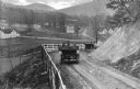
| Description: | Elevated view of two cars on a dirt road heading downhill. A town is in the valley below, and mountains are in the distance. |
| Date: | |
|---|---|
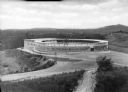
| Description: | Elevated view of the exterior of Liberty Heights Swimming Pool, a circular structure standing on a hilltop. Stairs lead to a door labeled, "Exit," where a ... |

| Date: | |
|---|---|
| Description: | Elevated view of a road and river winding through a mountainous landscape, seen from Waterlick White Hotel. Caption reads: "View from Hotel, Waterlick whit... |

| Date: | |
|---|---|
| Description: | Elevated view of a colony of residences in a mountain setting. |

| Date: | |
|---|---|
| Description: | Elevated view of the Blue Ridge Terrace, a large hotel on a mountain overlooking the valley. Cars are parked near the road, and three men are gathered on t... |

| Date: | 1864 |
|---|---|
| Description: | This battlefield map of the Battle of Totopotomoy Creek, also known as the Battle of Bethesda Church, shows the railroads, roads, vegetation and topography... |

| Date: | 1864 |
|---|---|
| Description: | This battlefield map of the Battle of Totopotomoy Creek, also known as the Battle of Bethesda Church, shows the railroads, roads, vegetation and topography... |

| Date: | 1864 |
|---|---|
| Description: | This map of the area of the First Battle of Bull Run shows military positions and troop movements as well as the names of landowners, vegetation and land u... |

| Date: | 1864 |
|---|---|
| Description: | This map created during the Civil War indicates Confederate fortifications, houses, names of residents, towns, roads, railroads, relief by hachures, draina... |

| Date: | 1865 |
|---|---|
| Description: | This map of the battlefield at Spotsylvania Courthouse illustrates the Union positions in blue and Confederate positions in red. Roads, railroads, vegetati... |

| Date: | 1865 |
|---|---|
| Description: | This map of the battlefield at Five Forks, Va., shows Union and Confederate positions, roads, drainage, vegetation, relief by hachures, and names of reside... |

| Date: | 1865 |
|---|---|
| Description: | Map extends from Harper's Ferry in the north to Petersburg in the south and from Lexington east to Heathsville. The routes of the II, V, VI, IX, XVIII, and... |

| Date: | 1865 |
|---|---|
| Description: | This detailed map of the area between Richmond and Petersburg shows fortifications, roads, railroads, towns, street patterns of Petersburg and Richmond, dr... |

| Date: | 1865 |
|---|---|
| Description: | The map of the battlefield shows entrenchments, villages, roads, the "South Side Rail Road" drainage, vegetation, relief by hachures, houses, and names of ... |

| Date: | 1950 |
|---|---|
| Description: | View of the changing of the guard at the Tomb of the Unknown Soldier in Arlington Cemetery. |

| Date: | 1865 |
|---|---|
| Description: | This map shows Union and Confederate lines on May 5th, 6th, and 7th, 1864. The lower left corner includes a key of symbols for batteries, turnpikes, plank ... |

| Date: | 1755 |
|---|---|
| Description: | Map of Virginia and parts of Maryland, North Carolina, and New Jersey. It shows borders, boundary lines, some Native American land, counties, cities, towns... |

| Date: | 1762 |
|---|---|
| Description: | Map of Virginia and parts of Maryland. It shows borders, boundary lines, Native American tribes and land, towns, forts, roads, mountains, waterfalls, bays,... |

| Date: | 1781 |
|---|---|
| Description: | Map of the southern portion of the Chesapeake Bay and surrounding lands. It shows counties, a few cities and towns, forts, roads, islands, topographical fe... |
| Date: | |
|---|---|
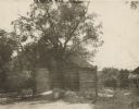
| Description: | View towards the mill. There is an exterior chimney to the left of the door, and a wooden walkway leads up to the closed door on the right. A fence leads t... |
If you didn't find the material you searched for, our Library Reference Staff can help.
Call our reference desk at 608-264-6535 or email us at: