 Filter: Categories of Wisconsin Historical Images
Filter: State of Virginia
Filter: Subject of transportation
Filter: Categories of Wisconsin Historical Images
Filter: State of Virginia
Filter: Subject of transportation

| Date: | 1865 |
|---|---|
| Description: | This detailed map of the area between Richmond and Petersburg shows fortifications, roads, railroads, towns, street patterns of Petersburg and Richmond, dr... |

| Date: | 1865 |
|---|---|
| Description: | The map of the battlefield shows entrenchments, villages, roads, the "South Side Rail Road" drainage, vegetation, relief by hachures, houses, and names of ... |

| Date: | 1950 |
|---|---|
| Description: | Men and women boarding a coach bus. The bus driver stands outside leaning against the front of the bus. Several people are seated in the bus seats with the... |

| Date: | 1950 |
|---|---|
| Description: | A young man posing with two bus drivers in front of a row of buses parked on the side of the road. Several vehicles are parked in a parking lot across the ... |

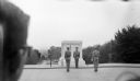
| Date: | 1950 |
|---|---|
| Description: | View of the changing of the guard at the Tomb of the Unknown Soldier in Arlington Cemetery. |
| Date: | 1950 |
|---|---|
| Description: | Changing of the guard at the Tomb of the Unknown soldier. The back of a man's head is in the foreground on the left. |

| Date: | 1862 |
|---|---|
| Description: | This map shows the plan of the siege of Yorktown and the Battle of Williamsburg. The map also shows fortifications, towns, roads, houses, names of resident... |

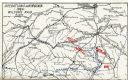
| Date: | 1865 |
|---|---|
| Description: | This map shows U.S. cavalry positions in yellow, Confederate infantry positions in blue, and Confederate cavalry positions in red. The map also shows roads... |

| Date: | 1865 |
|---|---|
| Description: | This map shows Union and Confederate lines on May 5th, 6th, and 7th, 1864. The lower left corner includes a key of symbols for batteries, turnpikes, plank ... |

| Date: | 1755 |
|---|---|
| Description: | Map of Virginia and parts of Maryland, North Carolina, and New Jersey. It shows borders, boundary lines, some Native American land, counties, cities, towns... |

| Date: | 1762 |
|---|---|
| Description: | Map of Virginia and parts of Maryland. It shows borders, boundary lines, Native American tribes and land, towns, forts, roads, mountains, waterfalls, bays,... |

| Date: | 1781 |
|---|---|
| Description: | Map of the southern portion of the Chesapeake Bay and surrounding lands. It shows counties, a few cities and towns, forts, roads, islands, topographical fe... |
| Date: | 1909 |
|---|---|
| Description: | Map showing operations in Virginia during Wilson's Raid. |
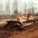
| Date: | 01 20 1972 |
|---|---|
| Description: | Man operating TD25c Dozer to move earth. Caption reads: "Williams Paving Company has contract to reconstruct and relocate 2.686 miles of route US 60 in New... |
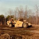
| Date: | 01 20 1972 |
|---|---|
| Description: | Man operating E 211 Pay Scraper. Caption reads: "Williams Paving Company has contract to reconstruct and relocate 2.686 miles of route US 60 in Newport New... |
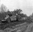
| Date: | 01 19 1972 |
|---|---|
| Description: | Man operating construction equipment, including a Pay Scraper and Dozer. Caption reads: "Williams Paving Company has contract to reconstruct and relocate 2... |

| Date: | |
|---|---|
| Description: | View toward the entrance to the manor house at Walnut Grove. A fence surrounds the house, and a man is standing near an automobile parked on the left behin... |
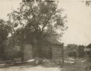
| Date: | |
|---|---|
| Description: | View towards the mill. There is an exterior chimney to the left of the door, and a wooden walkway leads up to the closed door on the right. A fence leads t... |
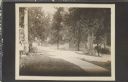
| Date: | 07 15 1909 |
|---|---|
| Description: | Postcard of the new cement driveway. The corner of the house is in the left foreground, and at the entrance to the drive is a gate and fence. On the right ... |

| Date: | 07 14 1909 |
|---|---|
| Description: | View looking towards the gate and fenced entrance of the new cement driveway. A building, perhaps a garage, is behind the fence on the left. The house is b... |
If you didn't find the material you searched for, our Library Reference Staff can help.
Call our reference desk at 608-264-6535 or email us at: