 Filter: Community of Summit
Filter: Subject of human settlements
Filter: Community of Summit
Filter: Subject of human settlements

| Date: | 1928 |
|---|---|
| Description: | The John MacDonald Tavern, built about 1852 about 2 miles west of Delafield, also known as the half-way house between Milwaukee and Madison. |

| Date: | 1928 |
|---|---|
| Description: | The John MacDonald Tavern, built about 1852 about 2 miles west of Delafield, also known as the half-way house between Milwaukee and Madison. |

| Date: | 1928 |
|---|---|
| Description: | The Summit Center Chapel. At the the time this picture was taken the chapel was no longer in use. |
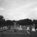
| Date: | 07 1965 |
|---|---|
| Description: | A grave in a segregated cemetery photographed by a civil rights volunteer, who notes that the Caucasian cemetery uses town funding while the African-Americ... |
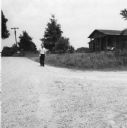
| Date: | 07 1965 |
|---|---|
| Description: | A man stands on the road outside a home shortly after civil rights volunteers depart from canvassing. "Leaving a house (on the right) after canvassing. B... |
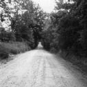
| Date: | 07 1965 |
|---|---|
| Description: | A rural road canvassed and photographed by a civil rights volunteer. "'A country mile' - one road to canvass in Summit, Miss. Actually the shaded part of... |
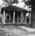
| Date: | 07 1965 |
|---|---|
| Description: | A home canvassed by a civil rights volunteer. "One of the 'better' homes that was canvassed in Summit. This one could also represent many homes in Hattie... |
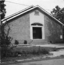
| Date: | 07 1965 |
|---|---|
| Description: | A church building photographed by a civil rights volunteer. "The 4th Sunday church of Summit. Rev. Ned Taylor, pastor. After church, Rev. Taylor invited ... |
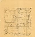
| Date: | 1925 |
|---|---|
| Description: | This map shows township sections, roads, railroads, and lakes. The map also features extensive manuscript annotations noting landownership in pencil. Stamp... |
If you didn't find the material you searched for, our Library Reference Staff can help.
Call our reference desk at 608-264-6535 or email us at:

