 Filter: FULL_DATE of 1848
| Date: | 1848 |
|---|---|
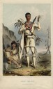
| Description: | Redbird, a Winnebago Indian, following his surrender after an attack on Prairie du Chien in 1827. |

| Date: | 1848 |
|---|---|
| Description: | In 1849, northern Wisconsin was composed of huge sectional regions such as Chippewa, Portage, Brown and Crawford, whereas southern Wisconsin was constitute... |
| Date: | 1848 |
|---|---|
| Description: | Photographic reprint of a daguerreotype of Cyrus Hall McCormick (1809-1884). McCormick was a Chicago industrialist and inventor in 1831 of the first commer... |
| Date: | 1848 |
|---|---|
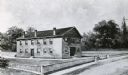
| Description: | Sketch of the Madison Women's Seminary on the corner of Wisconsin Avenue and East Johnson. The Madison Female Academy was a 19th century school for girls w... |

| Date: | 1848 |
|---|---|
| Description: | The first Fort Crawford at Prairie du Chien, with the Mississippi River in the foreground. Although dated 1830, this scene was actually painted by Henry Le... |

| Date: | 1848 |
|---|---|
| Description: | Studio portrait of Abraham Lincoln, from the original daguerreotype owned by his son, Robert T. Lincoln. |
| Date: | 1848 |
|---|---|
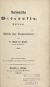
| Description: | Title page for the book "Nord-Amerika, Wisconsin, Calumet," by Dr. Carl de Haas. |

| Date: | 1848 |
|---|---|
| Description: | Foldout map of a sketch of the town grid of Calumet. |

| Date: | 1848 |
|---|---|
| Description: | Sixth plate daguerreotype of a seated woman in a long-sleeve printed dress and shoulder-length side curls, holding a sleeping baby on her lap with her righ... |

| Date: | 1848 |
|---|---|
| Description: | Immigrant map. |
| Date: | 1848 |
|---|---|
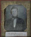
| Description: | Sixth plate daguerreotype waist-up portrait of Van Swearingen Brady of Ohio, son of Captain Samuel Brady. |
| Date: | 1848 |
|---|---|
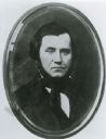
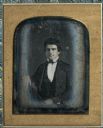
| Description: | Half plate daguerreotype of Nelson Dewey (1813-1889). Waist -up, facing forward, wearing suit and with right arm resting on a surface. Dewey was Governor o... |

| Date: | 1848 |
|---|---|
| Description: | A map of the Wisconsin and Iowa territories, with the surveyed counties of southern Wisconsin and eastern Iowa identified. The map shows the sectioning of ... |

| Date: | 1848 |
|---|---|
| Description: | Map of Wisconsin and a portion of Minnesota showing the township surveys in progress in portions of the Saint Croix River region and in central Wisconsin a... |

| Date: | 1848 |
|---|---|
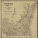
| Description: | Wisconsin became the thirtieth state in 1848. Drawn that same year, this map shows township lines, roads, villages, mills, railroads, prairies, swamps, can... |

| Date: | 1848 |
|---|---|
| Description: | This map by Increase Lapham shows the township and range system in southern and eastern Wisconsin as well as along the Wisconsin River in present-day Marat... |
| Date: | 1848 |
|---|---|
| Description: | This map shows the township and range system in southern and eastern Wisconsin as well as along the Wisconsin River in present-day Marathon, Portage, and W... |

| Date: | 1848 |
|---|---|
| Description: | Photographic print of an itinerary for Wisconsin Stage Lines operated by John Frink & Co. copied from an 1848-1849 Milwaukee City Directory. The advertisem... |
| Date: | 1848 |
|---|---|
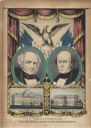
| Description: | A campaign poster for Free Soil Party candidates Martin Van Buren and Charles Francis Adams for President and Vice-President. Above is the American eagle, ... |

| Date: | 1848 |
|---|---|
| Description: | Pen-and-ink on paper. The title of the map is inscribed on the back. The map shows buildings, roads, marshes, wild rice, piles and docks, deep water, and o... |
If you didn't find the material you searched for, our Library Reference Staff can help.
Call our reference desk at 608-264-6535 or email us at: