 Filter: Subject of barracks
Filter: Subject of fortification
Filter: Subject of barracks
Filter: Subject of fortification
| Date: | |
|---|---|
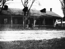
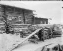
| Description: | Old Barracks at Fort Howard, exterior building. |
| Date: | |
|---|---|
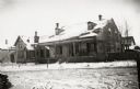
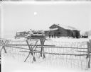
| Description: | View of the barracks on at the edge of a snow-covered street. |
| Date: | |
|---|---|
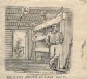
| Description: | Drawing of a soldier holding a cup, standing next to his bunk at Fort Holt. Civil War firearms are in the closet on the right. Another man is in the backgr... |
| Date: | 1862 |
|---|---|
| Description: | Fort Lincoln, Kansas, when the 12th Wisconsin Volunteers arrived on their march from Fort Scott to Lawrence. A watercolor by John Gaddis of Company E. |

| Date: | 1864 |
|---|---|
| Description: | Fort Crawford was decommissioned in 1856, having outlived its usefulness as a frontier post. During the Civil War, however, it functioned as a military ho... |

| Date: | |
|---|---|
| Description: | Elevated view of Fort Seward from Mount Rippinsky, showing Pyramid Harbor and Davidson Glacier in distance. Caption reads: "Haines and Fort Wm. H. Seward f... |

| Date: | 1816 |
|---|---|
| Description: | This is a photostat copy of a manuscript map in the National Archives showing a plan of Fort Howard and a view of its north side. Originally surveyed by Wi... |
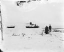
| Date: | 1918 |
|---|---|
| Description: | Trenches constructed for American forces to defend against the Bolshevik "Red" forces. In the background are possibly barracks and other buildings for the ... |
| Date: | 1918 |
|---|---|
| Description: | A group of possibly both American and British soldiers standing just outside a blockhouse fortification. There are piles of logs and an axe on the ground i... |
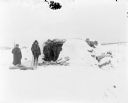
| Date: | 1918 |
|---|---|
| Description: | View across snow of two soldiers standing outside a blockhouse fortification. One soldier is wearing heavy wool furs and is armed with a rifle, and the oth... |
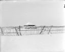
| Date: | 1918 |
|---|---|
| Description: | View across snow and through barbed wire fence towards a timber constructed blockhouse. More buildings and a forested area are in the far background. |
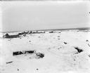
| Date: | 1918 |
|---|---|
| Description: | A shell-proof shelter alongside other buildings, possible a soldiers' barracks. In the distance there are two men placing wood on a horse-drawn sled. Anoth... |
| Date: | 1918 |
|---|---|
| Description: | View over barbed wire fence towards men standing outside a blockhouse and barracks. Immediately outside of the barracks is a horse-drawn mobile kitchen and... |

| Date: | 1837 |
|---|---|
| Description: | This map shows planned military posts/depots, barracks, rivers, lakes, roads, existing forts, and land assigned to various Indian tribes. Arkansas, Illinoi... |

| Date: | 03 1777 |
|---|---|
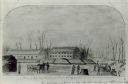
| Description: | Map showing the British and Hessian attack on Fort Washington in November of 1776. The movements and fortifications of the British and Hessian troops appea... |
If you didn't find the material you searched for, our Library Reference Staff can help.
Call our reference desk at 608-264-6535 or email us at: