 Filter: Subject of clothing
Filter: Subject of lakes
Filter: Subject of clothing
Filter: Subject of lakes

| Date: | 1835 |
|---|---|
| Description: | Little Lake Butte Des Morts just north of Lake Winnebago where Governor Lewis Cass of Michigan, and Thomas McKenney, head of the Bureau of Indian Affairs (... |

| Date: | 1941 |
|---|---|
| Description: | Hand-drawn, watercolor and ink, map of Lake Mendota. Locations and many small figures appear around the shore with explanations referring to Indian legends... |

| Date: | 1924 |
|---|---|
| Description: | Label submitted to the state of Wisconsin for trademark registration. "Blatz Waukesha Water, Bottled at the Springs, Waukesha WI, A natural spring water, s... |

| Date: | 1939 |
|---|---|
| Description: | Label submitted to the state of Wisconsin for trademark registration. "Superfine Marathon Beer, Marathon City Brewing Company." In the foreground of the im... |

| Date: | 1979 |
|---|---|
| Description: | A map of Southern Wisconsin and northern Illinois showing the areas inhabited by the Ho-Chuck, formerly known as the Winnebago. Some of the location names ... |
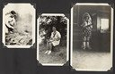
| Date: | |
|---|---|
| Description: | Page from Joy Camps photo album displaying three photographs. In one photograph Barbara Ellen Joy, camp owner and co-director, cooks over a large grill are... |

| Date: | 1630 |
|---|---|
| Description: | One of the few maps by Dutch cartographer Willem Blaeu depicting the Americas, this map shows regions, settlements, islands, mountains, forests, rivers, an... |

| Date: | 1759 |
|---|---|
| Description: | Map of North and South America showing regions, colonies, cities and settlements, rivers, lakes, and Native American land. Near the bottom left an inset ma... |

| Date: | 1636 |
|---|---|
| Description: | Map of North America, divided into regions, and showing some rivers, lakes, settlements, cities, mountains, and Native American land. Of the Great Lakes on... |

| Date: | 1770 |
|---|---|
| Description: | Map of North America from the Great Lakes to the northern portion of South America. It shows cities, Native American land, mountains, swamps, lakes, rivers... |

| Date: | 1720 |
|---|---|
| Description: | Detailed, ornate, and comprehensive map of America from the east coast to present day Texas. Numerous features appear throughout the map, including Native ... |

| Date: | 1911 |
|---|---|
| Description: | Indian women paddle their canoes on Rainy Lake. Other people and dogs are on the shore. |

| Date: | 1957 |
|---|---|
| Description: | Text on front reads: "Greetings from Sheboygan, Wisconsin. She-Boy-Again." Large Letter style postcard with a scene of an Indian village along a lake or ri... |
If you didn't find the material you searched for, our Library Reference Staff can help.
Call our reference desk at 608-264-6535 or email us at: