 Filter: Subject of political science
Filter: Subject of waterfalls
Filter: Subject of political science
Filter: Subject of waterfalls
| Date: | |
|---|---|
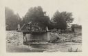
| Description: | View from shoreline towards the Milwaukee Journal Pathfinder car parked on a bridge. Under the bridge is a stream with a small waterfall. Two women are sta... |

| Date: | |
|---|---|
| Description: | Passengers aboard a cable car prepare for their trip over Niagara Falls. |

| Date: | 09 04 1885 |
|---|---|
| Description: | Exterior and interior bill of fare from The Chequamegon, with views on the back of rock formations, waterfalls, a spot illustration of a train going over a... |

| Date: | 1758 |
|---|---|
| Description: | This map of the north-west hemisphere shows the cities, lakes, rivers, mountains, and political borders. In the upper left corner sits a decorative cartouc... |

| Date: | 1783 |
|---|---|
| Description: | This map is hand-colored and shows the boundaries of British, Spanish, and the newly recognized American claims, as well as the fishing rights granted to F... |

| Date: | 1766 |
|---|---|
| Description: | This map of North America shows the boundaries of European claims at the end of the French and Indian war. The British colonies extend to the Mississippi. ... |

| Date: | 1780 |
|---|---|
| Description: | Map of North America east of Mexico showing colonial boundaries, forts, cities, Native American land, mountains, waterfalls, lakes, and rivers. Short notes... |

| Date: | 1760 |
|---|---|
| Description: | Map showing the towns, mountains, valleys, corn fields, and rivers of a portion of the Cherokee Nation. A few annotations on the map explain the land and r... |
If you didn't find the material you searched for, our Library Reference Staff can help.
Call our reference desk at 608-264-6535 or email us at: