 Filter: Subject of railroad bridges
Filter: Subject of land
Filter: Subject of industries
Filter: Subject of railroad bridges
Filter: Subject of land
Filter: Subject of industries
| Date: | |
|---|---|
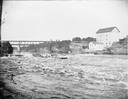
| Description: | Several men on a raft going over the dam at Munger's Mill. There is a railroad bridge in the background. |
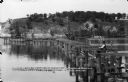
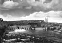
| Date: | 08 24 1886 |
|---|---|
| Description: | View across water of several men steering a lumber raft over the dam at Munger's Mill. A second raft is in the background, in front of railroad bridge. |

| Date: | 05 10 1919 |
|---|---|
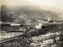
| Description: | Workers digging in a muddy trench near bridge no. 1, mine no. 2. Benham was a "company town" created by International Harvester for the workers of the Wisc... |
| Date: | 03 19 1919 |
|---|---|
| Description: | Small steam engine hauling empty cars over a bridge along a narrow gauge railroad track. Houses in a residential neighborhood are in the background. The tr... |

| Date: | 1893 |
|---|---|
| Description: | Bird's-eye map of Jefferson, looking north. Crayfish River at left and center, Rock River from upper center to bottom center, joins at left of center; thir... |

| Date: | 1883 |
|---|---|
| Description: | Bird's-eye map of Prairie du Sac, Wisconsin with an inset of Clifton. |

| Date: | 1879 |
|---|---|
| Description: | Bird's-eye map of Two Rivers. |
| Date: | 09 01 1882 |
|---|---|
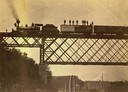
| Description: | View looking up towards the special train of the Chicago, St. Paul, Minneapolis & Omaha Railroad comprised of 24 freight cars loaded with lumber and other ... |
| Date: | 09 29 1963 |
|---|---|
| Description: | The Menasha Woodenware plant and water tower on Doty Island from across the Fox River canal, with a small railroad dolly in the foreground. |
| Date: | 09 29 1963 |
|---|---|
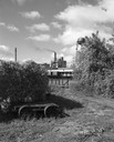
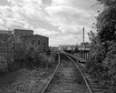
| Description: | View down railroad tracks towards the railroad bridge, with industrial plants on Doty Island. |
| Date: | |
|---|---|
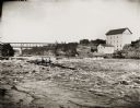
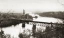
| Description: | Elevated view of the river with multiple bridges across it, including at least two railroad bridges. There is a factory on the left bank with smokestacks, ... |
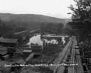
| Date: | 1905 |
|---|---|
| Description: | Elevated view toward the lumber company. A bridge over a river is in the foreground. Caption reads: "Looking South from City Hall Tower, Wausau, Wis." |
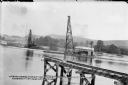
| Date: | 06 19 1911 |
|---|---|
| Description: | Looking west over the Wisconsin River at the unfinished narrow gauge railroad trestle built for construction of the dam. Two pile drivers are seen in the a... |
| Date: | 06 21 1911 |
|---|---|
| Description: | Looking east over the Wisconsin River showing the unfinished narrow gauge railroad trestle. Two steam-driven pile drivers on barges with construction worke... |
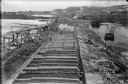
| Date: | 03 11 1914 |
|---|---|
| Description: | Elevated view looking east from the lock at the Prairie du Sac dam. Recently completed buttresses are in the foreground, with earlier stages of constructio... |
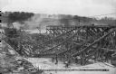
| Date: | 05 17 1912 |
|---|---|
| Description: | Elevated view of workers using shovels to level fresh concrete at the base of the chutes from the high trestle. The steam powered pile driver is at work in... |

| Date: | |
|---|---|
| Description: | View of a train passing over the W. & G.N. wooden railroad bridge which spans a mountain pass. Lumber is in the valley below. Caption reads: "W. & G.N. Br... |
| Date: | 1910 |
|---|---|
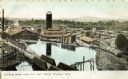
| Description: | Elevated view looking upriver toward the Dells Paper and Pulp Company factory which stands near a dam on the Chippewa River. A bridge, smokestacks, and sev... |
| Date: | 08 29 1930 |
|---|---|
| Description: | View from top of new bridge of construction grounds at the bridge site. There are cars carrying building materials on the railroad tracks by the Bridgeport... |

| Date: | 09 1884 |
|---|---|
| Description: | Sanborn map of Fort Atkinson including Barrie, Germany, and North Water Streets. |
If you didn't find the material you searched for, our Library Reference Staff can help.
Call our reference desk at 608-264-6535 or email us at: