 Filter: Subject of revolution, 1775-1783
Filter: Subject of hills
Filter: Subject of revolution, 1775-1783
Filter: Subject of hills
| Date: | |
|---|---|
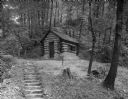
| Description: | A set of stone stairs leads to a small soldiers' hut inhabited during the American Revolution. This view of the hut in a wooded area shows a door, a window... |

| Date: | 1780 |
|---|---|
| Description: | Detailed topographical and political map of the area from Lake Champlain to Albany and the Hudson River. Relief is shown through hachures. The map shows ci... |

| Date: | 10 1776 |
|---|---|
| Description: | Broadside map showing the British invasion of New York city in August and September of 1776. The map shows important cities, forts, roads, hills, mountains... |

| Date: | 02 1777 |
|---|---|
| Description: | Map depicting the campaigns of October and November 1776, in Manhattan, Westchester, and part of New Jersey, published only a few months after the conclusi... |

| Date: | 03 1777 |
|---|---|
| Description: | Map showing the British and Hessian attack on Fort Washington in November of 1776. The movements and fortifications of the British and Hessian troops appea... |

| Date: | 11 1781 |
|---|---|
| Description: | Map of New York, Staten Island, and Long Island, showing the placements of forts, and the movement of troops in 1776. The map also includes towns, cities, ... |

| Date: | 04 1777 |
|---|---|
| Description: | Map showing the area from Newtown, Pennsylvania to Kingston, New Jersey, with routes and battles of British (red) and American forces (blue). The map inclu... |
If you didn't find the material you searched for, our Library Reference Staff can help.
Call our reference desk at 608-264-6535 or email us at: