 Filter: Subject of revolution, 1775-1783
Filter: Subject of veterans
Filter: Subject of revolution, 1775-1783
Filter: Subject of veterans
| Date: | 1850 |
|---|---|
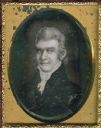
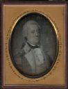
| Description: | Ninth plate daguerreotype of a painted quarter-length portrait of Felix Walker, 1793-1828. Mr. Walker fought in the Revolutionary War alongside Daniel Boon... |
| Date: | 1850 |
|---|---|
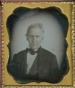
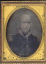
| Description: | Sixth plate daguerreotype, Quarter-length portrait of Josiah Ficklin. Hand coloring on cheeks. Ficklin was from Lexington, Kentucky, and one of the defende... |
| Date: | 1850 |
|---|---|
| Description: | Quarter plate daguerreotype of a painting of Colonel Robert Patterson (1753-1827). Patterson was a pioneer settler to both Kentucky and Ohio. He served in ... |
| Date: | 1850 |
|---|---|
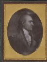
| Description: | Sixth plate daguerreotype of a painting of Colonel Robert Weakley. Col. Weakley served as a Representative from Tennessee; born in Halifax County, Va., Jul... |
| Date: | 1850 |
|---|---|
| Description: | Quarter plate daguerreotype of a painting of General William Irvine. The portrait shows General Irvine in his military uniform. General Irvine served as a ... |

| Date: | |
|---|---|
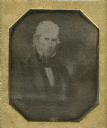
| Description: | Sixth plate ambrotype of a painting of Captain Samuel Murphy. Murphy served with Captain Samuel Brady in the Pittsburgh region during the Revolutionary War... |
| Date: | 1850 |
|---|---|
| Description: | Quarter plate daguerreotype of a painting of General George Rogers Clark, as an older man. Clark is most well known for his role in the defense of the Nort... |

| Date: | 1792 |
|---|---|
| Description: | Map of the United States east of the Mississippi River and north of the Ohio River. It shows the borders between the north eastern states, Canada and the U... |

| Date: | 1795 |
|---|---|
| Description: | Detailed map of Kentucky and most of Tennessee. The map shows the borders, counties, cities, towns, Native American towns, forts, roads, mountains, lakes, ... |
If you didn't find the material you searched for, our Library Reference Staff can help.
Call our reference desk at 608-264-6535 or email us at: