 Filter: Subject of rivers
Filter: Subject of menominee indians
Filter: Subject of rivers
Filter: Subject of menominee indians

| Date: | |
|---|---|
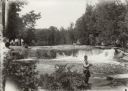
| Description: | A Menominee Indian Village on Wolf River. There are dwellings on the shore and many people in canoes are on the river. |
| Date: | 1920 |
|---|---|
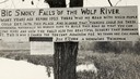
| Description: | Sign for the toll road at Big Smoky Falls on the Wolf River. The sign reads: "Big Smoky Falls of the Wolf River. Many years ago before 1925 there was no ro... |

| Date: | 04 1954 |
|---|---|
| Description: | A young Menominee Indian (Charles ?) pauses briefly for a photograph while straddling his bicycle. He is stopped on the road with the snow-covered Wolf Riv... |
| Date: | 1929 |
|---|---|
| Description: | Group of people at Bear Trap Falls in the Wolf River near Keshena. People are standing on the shoreline on the left near a sign for the falls. A man is sta... |
| Date: | |
|---|---|
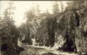
| Description: | Postcard of Route 55 Menominee Indian reservation, Dells of Wolf River. |

| Date: | 1938 |
|---|---|
| Description: | This map shows lakes, rivers, roads, trails, lookout towers, and railroads. |

| Date: | 1846 |
|---|---|
| Description: | A map of Wisconsin and a portion of Minnesota that show the township surveys in progress in portions of the Saint Croix River region and in central Wiscons... |

| Date: | 1848 |
|---|---|
| Description: | Map of Wisconsin and a portion of Minnesota showing the township surveys in progress in portions of the Saint Croix River region and in central Wisconsin a... |

| Date: | 1857 |
|---|---|
| Description: | A map of the state of Wisconsin and the southeastern portion of the Territory of Minnesota, showing the Wisconsin reservations of the Oneida, Menominee, St... |

| Date: | 1858 |
|---|---|
| Description: | A survey map that shows the status of township surveys in Wisconsin. At that point, the majority of the state had been surveyed and platted, with the area... |

| Date: | 1860 |
|---|---|
| Description: | A survey map of Wisconsin, southeastern Minnesota, and northern Iowa, showing the status of surveys, rivers, and lakes. The map also shows the locations of... |

| Date: | 1979 |
|---|---|
| Description: | A map of Southern Wisconsin and northern Illinois showing the areas inhabited by the Ho-Chuck, formerly known as the Winnebago. Some of the location names ... |

| Date: | 1855 |
|---|---|
| Description: | This map shows the entire state and part of the Upper Peninsula of Michigan. It depicts creeks, rivers, lakes, railroads completed, railroads in progress, ... |

| Date: | 1855 |
|---|---|
| Description: | This Wisconsin map depicts counties, creeks, rivers, lakes, railroads completed, railroads in progress, common roads and the Menomonee Reservation. |

| Date: | 1855 |
|---|---|
| Description: | This map depicts counties, creeks, rivers, lakes, railroads completed, railroads in progress, common roads and the Menomonee Reservation. |

| Date: | 1941 |
|---|---|
| Description: | Wisconsin counties, towns, cities, and selected villages, as well as the Menominee Indian Reservation are identified on this U.S. Bureau of the Census map ... |

| Date: | 1952 |
|---|---|
| Description: | This map shows counties, towns, cities, and selected villages, as well as the Menominee Indian Reservation are identified on this U.S. Post Office. Circles... |

| Date: | 1856 |
|---|---|
| Description: | This map with an ornamental border shows the township survey grid and identifies counties, named towns, cities and villages, rivers, lakes, railroads, road... |

| Date: | 1856 |
|---|---|
| Description: | This map of shows the township survey grid and identifies counties, named towns, cities and villages, rivers, lakes, railroads, roads, and the Menomonee an... |

| Date: | 1857 |
|---|---|
| Description: | This map depicts the township survey grid and identifies counties, named towns, cities and villages, rivers, lakes, railroads, roads, and the Menomonee and... |
If you didn't find the material you searched for, our Library Reference Staff can help.
Call our reference desk at 608-264-6535 or email us at: