Filter: Subject of rivers
Filter: Subject of religion
Filter: Subject of rivers
Filter: Subject of religion
| Date: | 10 14 1871 |
|---|---|
| Description: | Pilgrims kneeling and praying at the holy well near Galway, Ireland. |

| Date: | 1898 |
|---|---|
| Description: | Bird's-eye map of Milwaukee with prominent streets and buildings identified. Taken from City Hall Tower. |

| Date: | 1855 |
|---|---|
| Description: | Map of the city of Madison, Dane County, published by George Harrison, surveyed and drawn by P. McCabe, and engraved by J.H. Colton & Co., New York. In add... |

| Date: | 1960 |
|---|---|
| Description: | Aerial view of The Holy Family Convent and College, motherhouse of the Franciscan Sisters of Christian Charity, and liberal arts for the education of Siste... |

| Date: | 1840 |
|---|---|
| Description: | This map surveyed under the direction of Captain Thomas J. Cram is one in a series of seventeen that accompanied Cram's report on the Fox-Wisconsin river s... |

| Date: | 1948 |
|---|---|
| Description: | Two preliminary watercolors of the right panel of the Centennial Mural in the Wisconsin Historical Society. The panel displays the history of Wisconsin ex... |

| Date: | 1948 |
|---|---|
| Description: | A watercolor of the right panel of the Centennial Mural in the Wisconsin Historical Society. This panel displays the history of Wisconsin exploration, mos... |
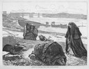
| Date: | 1876 |
|---|---|
| Description: | Distant view of Neshotah Mission. River with boaters, two people standing on riverbank, mission on hill in background. |
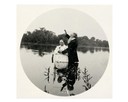
| Date: | 06 04 1894 |
|---|---|
| Description: | View of a church boat called "Bethel" on the river. |

| Date: | 1897 |
|---|---|
| Description: | A map of Wisconsin showing the self-supporting churches, Home Missionary churches, stations not organized, Sunday schools of C.S.S. Society, Congregational... |

| Date: | 1939 |
|---|---|
| Description: | This map shows the towns to Gingles, Sanborn, and Guney as well as Chequamegon Bay, Kakagon River, White River, Marengo River, Bad River, Potato River, Vau... |

| Date: | 1881 |
|---|---|
| Description: | A brochure with a map of Wisconsin that also includes information (in English, German, Norwegian, and Swedish) pertaining to the state, such as its timber ... |

| Date: | |
|---|---|
| Description: | Aerial view of a monastery and college with other buildings and landscaping. |

| Date: | 04 1980 |
|---|---|
| Description: | Shortly after their wedding at Saint Theresa Catholic Church, Eugene Bodden and his bride, Linda Johnson prepare to leave the church in a manure spreader. |

| Date: | 1940 |
|---|---|
| Description: | This map of Beaver Dam pictorially shows the history of the town. The map was made for the 100th anniversary celebration of Beaver Dam in 1941. The map inc... |
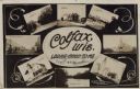
| Date: | 11 16 1908 |
|---|---|
| Description: | Photographic COLLAGE postcard of scenes of Colfax. In the center oval is the text, "Colfax, Wis. Looks Good To Me," however the "Looks Good To Me" is cross... |

| Date: | 1857 |
|---|---|
| Description: | This map shows rural landownership and acreages, lot and block numbers, selected buildings, roads, railroads, and public squares. The map is indexed for th... |

| Date: | 1911 |
|---|---|
| Description: | This map shows swamps, railroads, rivers, roads, the Catholic Mission Reserve, the day school, and the Agency Reserve. Lake Superior is labeled. An inset m... |

| Date: | 1845 |
|---|---|
| Description: | This map shows lakes, rivers, Chippewa land, the U.S. Mineral Land Agency, boundary between U.S. and Canada, Methodist and Catholic missions, and American ... |
If you didn't find the material you searched for, our Library Reference Staff can help.
Call our reference desk at 608-264-6535 or email us at: