 Filter: Year of 1800-1899
Filter: Subject of cities and towns
Filter: Type of Map or Atlas
Filter: Year of 1830-1839
Filter: Year of 1800-1899
Filter: Subject of cities and towns
Filter: Type of Map or Atlas
Filter: Year of 1830-1839
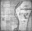
| Date: | 1836 |
|---|---|
| Description: | Map of Milwaukee including the Milwaukee River and Lake Michigan shore. |

| Date: | 1836 |
|---|---|
| Description: | Map of all Dane County and eastern towns. |

| Date: | 1839 |
|---|---|
| Description: | This map shows the hydrology of Madison and its vicinity at the height of interest in a proposed Milwaukee and Rock River Canal. It was made by Thomas Jeff... |

| Date: | 1832 |
|---|---|
| Description: | Hand-drawn map in two parts of the route of Governor J.D. Doty. Probably made by Doty in 1832 as a result of his travels with Alexander J. Center. |

| Date: | 1836 |
|---|---|
| Description: | The top map is the "Plat of Madison the Capitol of Wisconsin." The bottom map is the "Map of the Four Lake Country. Taken from the Township Maps in the U.S... |

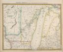
| Date: | 1836 |
|---|---|
| Description: | Map of the northern parts of Ohio, Indiana, and Illinois with Michigan and the part of "Ouisconsin" lying east of the Mississippi River. |

| Date: | 1831 |
|---|---|
| Description: | Map of the United States "constructed from the latest authorities," including a statistical table. |

| Date: | 03 30 1835 |
|---|---|
| Description: | Map of township # 7N, range no. 10 east, 4th meridian, including Third Lake. |

| Date: | 1830 |
|---|---|
| Description: | Multicolor map illustrates the development of states and territories in the Old Northwest. Wisconsin was on the frontier of settlement when this map was pu... |

| Date: | 1836 |
|---|---|
| Description: | The map of Wisconsin City on the Wisconsin River. |

| Date: | 07 01 1836 |
|---|---|
| Description: | Original plat map of the town of Madison on the four lakes. |

| Date: | 1838 |
|---|---|
| Description: | Compiled from the latest authorities. Published by Hinman and Dutton. |

| Date: | 1830 |
|---|---|
| Description: | Fort Winnebago from an original drawing by Jefferson Davis. |

| Date: | 1836 |
|---|---|
| Description: | Lots to be sold at auction by Van Antwerp and Van Dyke on Monday, 3rd Oct. 1836. The map shows plots and labeled streets. Iowa County was later split and B... |

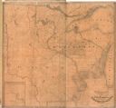
| Date: | 1839 |
|---|---|
| Description: | Shows locations of cities, towns, villages, post hamlets, canals, rail and stage roads. Includes table of steamboat routes and distances; vignette of "Maid... |
| Date: | 1833 |
|---|---|
| Description: | Published by Baldwin and Craddock under the superintendence of the Society for the Diffusion of Useful Knowledge, April 1, 1833. Printed by Russell Penge; ... |

| Date: | 1835 |
|---|---|
| Description: | Map reads: "Map of the United States of America with its Territories and Districts - Including also a part of Upper and Lower Canada and Mexico". The map i... |
| Date: | 1838 |
|---|---|
| Description: | Map of the entire territories of Iowa and Wisconsin. |

| Date: | 1835 |
|---|---|
| Description: | This map of Wisconsin Territory was compiled by public surveys in 1835; it is limited to modern-day southern Wisconsin. Included are two insets – one of th... |
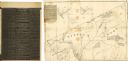
| Date: | 1838 |
|---|---|
| Description: | This map of the Wisconsin Territory, accompanied by the photostat of an article from the January 13, 1838, Wisconsin democrat, shows the area described as ... |
If you didn't find the material you searched for, our Library Reference Staff can help.
Call our reference desk at 608-264-6535 or email us at: