 Filter: Year of 1800-1899
Filter: Subject of cities and towns
Filter: Year of 1850-1859
Filter: Year of 1852
Filter: Year of 1800-1899
Filter: Subject of cities and towns
Filter: Year of 1850-1859
Filter: Year of 1852

| Date: | 1852 |
|---|---|
| Description: | Illustration of four Indians on Madeline Island with a canoe in the water on the shore. |

| Date: | 1852 |
|---|---|
| Description: | Pencil drawing of Madison landscape as seen from University Hill. The main street in the center is State Street, and the building with Greek columns in the... |

| Date: | 1852 |
|---|---|
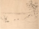
| Description: | Pencil drawing of view overlooking Madison. The sketch looks down North Hamilton Street from the capitol. Rutted, irregular streets and frame houses mark ... |
| Date: | 08 1852 |
|---|---|
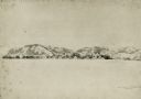
| Description: | Pencil drawing of a lake shoreline. A few trees frame the arc of the shore and steamboats are visible along the distant shore. |

| Date: | 08 1852 |
|---|---|
| Description: | Pencil drawing of Milwaukee Harbor with large sailboats on the water. In the minimalist depiction the sandy shoreline with short plant growth sweeps aroun... |

| Date: | 1852 |
|---|---|
| Description: | Map reads: "The State of Wisconsin- compiled from the latest authorities". In addition, there is a scale which is six miles for every inch, and a profile o... |
| Date: | 04 05 1852 |
|---|---|
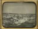
| Description: | Whole plate daguerreotype of view along the east bank of the Galena River (also known as the Fevre River). From a full plate daguerreotype by Alexander Hes... |
| Date: | 08 1852 |
|---|---|
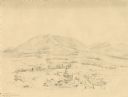
| Description: | Pencil drawing of Rattlesnake Bluff and the town of Arena from a distance across a plain. A row of buildings runs along the foot of the gently rolling hill... |
| Date: | 1852 |
|---|---|
| Description: | Landscape featuring a rural city center with a prominent courthouse surrounded by fields and woods. Rolling erosion-softened mountains rise in the backgro... |
| Date: | 1852 |
|---|---|
| Description: | This manuscript map shows the portage of the Wisconsin and Fox rivers at Fort Winnebago, the course of the Fox River in Columbia and Marquette counties, an... |

| Date: | 1852 |
|---|---|
| Description: | A hand-colored map showing portions of present-day Iron and Vilas counties north of the Manitowish River as part of the Upper Peninsula of Michigan. The Wi... |

| Date: | 1852 |
|---|---|
| Description: | Map shows Wisconsin counties by color and includes rivers, lakes and some cities. This information is also given for eastern Minnesota and northern Illinoi... |

| Date: | 01 01 1852 |
|---|---|
| Description: | These manuscript maps, drawn by William H. Canfield in 1852, illustrate mounds primarily in Sauk County, Wisconsin, in the towns of Greenfield, La Valle, M... |

| Date: | 1852 |
|---|---|
| Description: | On left side map reads: "Note by the lithographer on the Original Plat there is a Certificate of Record signed by Resister of Dane Co. also a Certificate o... |

| pencil drawings |
| Ever wonder why beer is so popular in Wisconsin? Wisconsin history is full of breweries and beer. |
| Learn more about the 1904 fire that destroyed the third Wisconsin State Capitol. |
| Madison's 150th Anniversary |
|---|
| View this collection of images of Madison, Wisconsin from the collections of the Wisconsin Historical Society. |
| View these 19th-century panoramic, detailed maps of Wisconsin communities. |
| View a pictorial review of the Wisconsin State Fair from 1851 when it began. |
If you didn't find the material you searched for, our Library Reference Staff can help.
Call our reference desk at 608-264-6535 or email us at: