 Search: Madison
Filter: Categories of Wisconsin Historical Images
Filter: Year of 1900-1999
Filter: Subject of human settlements
Filter: Year of 1960-1969
Filter: Year of 1963
Search: Madison
Filter: Categories of Wisconsin Historical Images
Filter: Year of 1900-1999
Filter: Subject of human settlements
Filter: Year of 1960-1969
Filter: Year of 1963
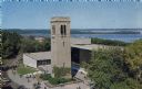
| Date: | 1963 |
|---|---|
| Description: | Elevated view of the Carillon Tower and Social Science Building, on the University of Wisconsin-Madison campus. Picnic Point and Lake Mendota are in the ba... |
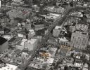
| Date: | 1963 |
|---|---|
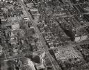
| Description: | Aerial view of downtown Madison focused on Mifflin and Fairchild Streets with the site of the new Madison Public Library marked. Mifflin Street runs diagon... |
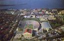
| Date: | 1963 |
|---|---|
| Description: | Aerial view of Camp Randall during a football game on the University of Wisconsin-Madison campus with Picnic Point in the background. |
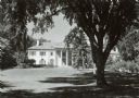
| Date: | 1963 |
|---|---|
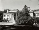
| Description: | The Executive Mansion, 99 Cambridge Road, in Maple Bluff. |
| Date: | 1963 |
|---|---|
| Description: | The front facade of the Executive Mansion, 99 Cambridge Road, Maple Bluff. |

| Date: | 05 22 1963 |
|---|---|
| Description: | View of the Wisconsin State Capitol, probably from Martin Luther King Jr Boulevard. |

| Date: | 11 29 1963 |
|---|---|
| Description: | Crowded with cars and shoppers, a holiday-decorated State Street is featured as Christmas shopping begins on the day after Thanksgiving. |
| Date: | 1963 |
|---|---|
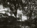
| Description: | Detail of the Executive Mansion through garden shrubbery. The residence is located at 99 Cambridge Road in Maple Bluff. |

| Date: | 10 29 1963 |
|---|---|
| Description: | Groundbreaking ceremony for the new Madison Public Library building at the south corner of W. Mifflin and N. Fairchild Streets. Rev. Joseph Brown is standi... |
| Date: | 1963 |
|---|---|
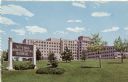
| Description: | Exterior view of a VA Hospital from across a lawn with small trees. |

| Date: | 01 1963 |
|---|---|
| Description: | View from street of businesses along West Main Street, long after the remodeling of the Blied Building, 29 West Main Street, when the top two stories were ... |

| Date: | 11 05 1963 |
|---|---|
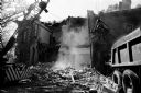
| Description: | A bulldozer demolishing St. Joseph's Catholic Church at 10 South Park Street as part of the Triangle area urban renewal project. |
| Date: | 11 26 1963 |
|---|---|
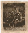
| Description: | Original UPI Wirephoto transmission. Caption reads: "Even the statue of Abraham Lincoln on the University of Wisconsin campus seemed more somber 11/25 than... |

| Date: | 05 02 1963 |
|---|---|
| Description: | Street view of the newly finished Park Motor Inn on Madison's Capitol Square. The steeple of St. Raphaell's Cathedral is on the left. |
| Date: | 1963 |
|---|---|
| Description: | Aerial view showing University Avenue running diagonally from top to bottom. Chadbourne Hall at the intersection of University and N. Park Street is at bot... |
| Date: | 05 23 1963 |
|---|---|
| Description: | The 104-year old Vilas Mansion at 12 Gilman Street is demolished to make way for the new National Guardian Life Insurance Co. building. The house was built... |
| Date: | 05 20 1963 |
|---|---|
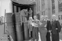
| Description: | Barrels of supplies to stock area fallout shelters being unloaded at the City-County Building by work relief program participants and Huber law prisoners f... |
| Date: | 1963 |
|---|---|
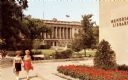
| Description: | Color postcard of the exterior of the State Historical Society of Wisconsin from across the Library Mall. The University of Wisconsin Memorial Library is o... |
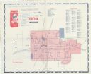
| Date: | 1963 |
|---|---|
| Description: | A map with handwritten notes and locations for Freedom Fighters participating in the Canton Boycott, for orientation during picketing. It is not a map show... |

| Date: | 1963 |
|---|---|
| Description: | This colored road map shows automobile roads in Wisconsin as well as portions of nearby states. The map is organized such that a single map of Wisconsin is... |
If you didn't find the material you searched for, our Library Reference Staff can help.
Call our reference desk at 608-264-6535 or email us at: